Light at the End of the Pain Tunnel: Surgery and Initial Recovery

header

In my previous post I described what turned out to be 6 months of waiting for total hip replacement surgery, including being scheduled once, then cancelled, then scheduled again, due to healthcare system responses and adaptations to the coronavirus pandemic.  During this period of time I had a few discussions with a good friend who, besides being perceptive, has close secondhand experience with joint replacement surgery.  One time, not too long before the surgery was rescheduled, we talked about a pain tunnel and being able, at some point, to see the end of it coming into view.  My pain was not actually very severe, but I had been living with it off-and-on, mostly on, for a few years – so I appreciated the mental visualization.  Indeed, I’d had very few days that were completely pain-free.  Certainly I was hoping that, when I thought I was starting to see light, it wasn’t the proverbial train coming the other way!

I paused my story in the previous post at the evening before the surgery.  I had done as much as I could to keep my body and spirits strong and to prepare various aids that I would need in the days immediately following the surgery.  I was acutely aware that the surgery was planned to be an outpatient procedure, so I’d hopefully be returning home late in the afternoon.

I had received a calendar, or timeline, describing several preparations I needed to do the evening before.  I was to shower and wash my hair, but use no deodorant or lotions.  After putting on a clean nightgown I was to wait one hour and then use some special wipes to wipe my body, a section at a time in a specific sequence essentially from top to bottom.  Then I was supposed to put on a new clean nightgown, not the same one I’d worn for an hour.  Of course, my towels and sheets had been freshly laundered, and my entire bathroom and sleeping area had recently been thoroughly cleaned.

My last opportunity to eat solid food was 8 hours prior to my scheduled arrival time at the hospital.  That magic time happened to be 2am, so I had a small snack around 10pm.  There was a special routine for brushing my teeth.  I allowed for 8 1/2 hours in bed, and I actually slept quite well, avoiding a pre-big-event adrenaline rush.

I had been provided with a special pre-surgery drink consisting of complex carbs, to drink in the morning.  I was supposed to drink it within a 15-minute period, 2 hours before my arrival time.  I finished it at 8am on the dot.  Then there was another special tooth-brushing, and no more eating or drinking.  Of course I needed to dress in clean clothes.  I checked and re-checked the small bag of items I would take with me, and finally it was time to leave.

When I arrived at the hospital my partner and I went to the surgery admissions area and went through that process.  He provided his contact information to the hospital staff, I gave him the items I wouldn’t need any longer, and he left.  I was shown to a gurney in a curtained-off waiting room.  Shortly I was brought a hospital gown, hairnet, non-skid sock slippers, a belongings bag with my name and medical record number, and some more special wipes, even more than I had used the evening before.  Once I was settled on the gurney in my hospital gown some special covers were placed over me and I was bathed in warm air.

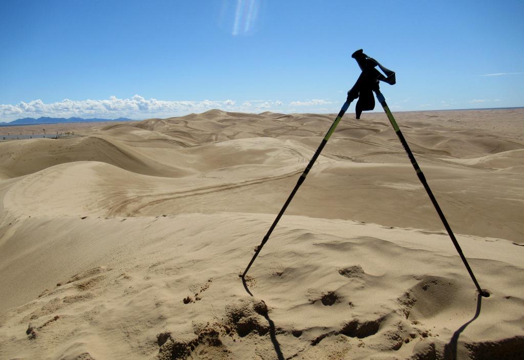
Several people came in and out, taking vitals and asking questions.  I confirmed multiple times that I was having total hip replacement surgery on my right hip.  My surgeon came in, confirmed my procedure once again, and initialed my right hip.  My anesthesiologist came in and we talked about how he was planning to sedate me (spinal plus a light general, the latter referred to today as sedation).  I had brought a printed copy of an anesthesiology joke that I’d recently run across on-line.  He had the good humor to accept the paper and put it away in a pocket.

photo of something for my anesthesiologist

Something for my anesthesiologist

At some point I had an opportunity to pee, and there was some waiting.  An IV was started in the back of my right hand.  I had brought a small MP3 player with me, and I started playing some relaxing music into my earbuds. The anesthesiologist came back in, I think, and had me sit up at the side of the bed while he pre-numbed me and gave me the spinal.

Suddenly I was being rolled away to the operating room.  Once it’s time, it’s time right now.  I’d removed my glasses but I could vaguely see a wall-mounted clock that read 11:50.  In the OR I was transferred to an operating table, positioned on my left side – to present my right hip upward – and propped up from behind, with my right hand (with IV) on another support structure.

After that I apparently was sedated, per the plan.  I knew what was supposed to happen during the surgery: the screws from the original repair would be removed, prior to all of the usual steps for a total hip replacement.  I did become slightly aware at some point, and I recall hearing some noises that sounded like tapping or hammering.  I surmised that the implant stem was being placed into my femur, and then I became unaware again.

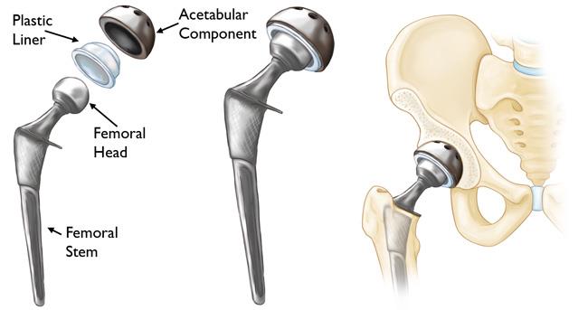
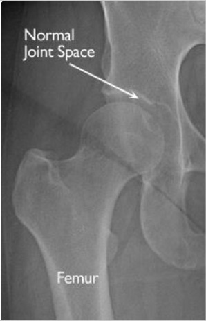
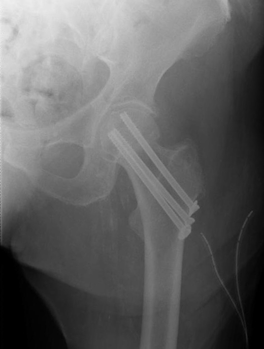
For reference, here is an article that describes the surgical procedure.  And this is what a hip implant looks like in an x-ray.  It’s not mine, but I presume it’s similar.
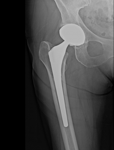
photo of typical hip implant

Typical hip implant

After a while I woke up in the recovery area, once again lying on my back on a gurney under some comfortable covers.  I suppose there was some more waiting, but I don’t remember much.  My surgeon came in and told me that the surgery had gone well.  I asked if the surface of the head of my femur had degraded further since my October x-ray, and she said it had.  My partner appeared, smiling encouragingly.  Somehow I got dressed and was coached by a physical therapist on how to get out of bed and stand up to use a walker to walk.  I must have taken at least a few steps.  I was still groggy, and undoubtedly had pain medication in my system.  My partner was then sent off to the pharmacy to pick up some medications and bring the car to the walk-in surgery entrance, where we had entered several hours prior.  I got my discharge instructions, got into a wheelchair, and was taken downstairs to my waiting vehicle, where I posed for a quick picture.  I had deliberately selected everything I wore that day – including the bandana I was using as a face covering, which said “Go outside and play!”  I was smiling behind the bandana.

photo of leaving the hospital after my surgery

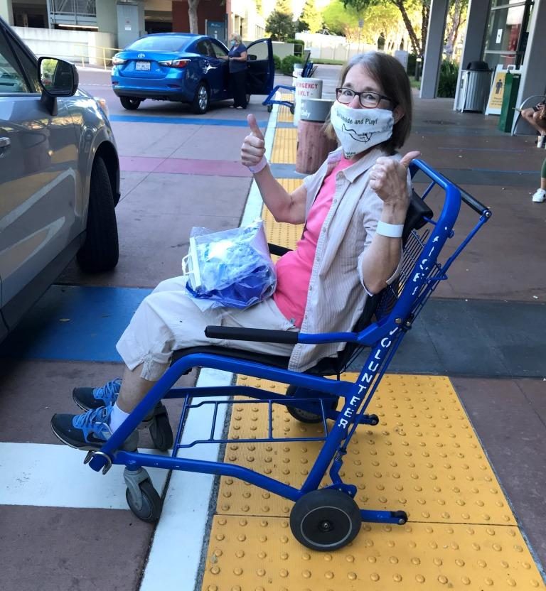
Leaving the hospital after my surgery

At home I used the walker to go into the house and walk to the couch, where I had pre-placed pillows to elevate my leg.  I had a snack, began taking some of the medications, and rested. I probably dozed off, since my sleep app data indicates I didn’t actually get into bed until after 11pm.  I slept fitfully.  I spent the entire next day, Day 1, on the couch, mostly dozing between having small meals, drinks, meds, and ice packs brought to me.

On Day 2 I had a Home Health Care physical therapy (PT) visit and was given a few exercises to begin, all of which I could do while reclined on the couch.  I was diligent about taking the pain meds I’d been prescribed, as the discharge instructions strongly recommended staying ahead of pain.

On Day 4 I managed to sit up for an hour or so in a well-cushioned chair to attend a Zoom session (I didn’t need to do anything other than listen).  The next day, Day 5, I attended another Zoom session in which I presented several photos to a photography interest group.  I was already beginning to return to normal!

Earlier on Day 5 I’d had a second PT session at home.  In addition to progressing my exercises, the therapist changed the dressing over my incision.  I had been avoiding even touching the dressing, so I did not realize until then just how long my incision was.  The therapist measured it, and it was 7 inches long!  Here are a few pictures of the incision as it healed: on Day 5, Day 17, and Day 28.  It had been closed with resorbable sutures and surgical glue, so there was nothing that needed to be removed.  But I did have some “hanging chads” of glue around the end of the second week.

photo of my surgical incision on Day 5 (left), Day 17 (center), and Day 28 (right)

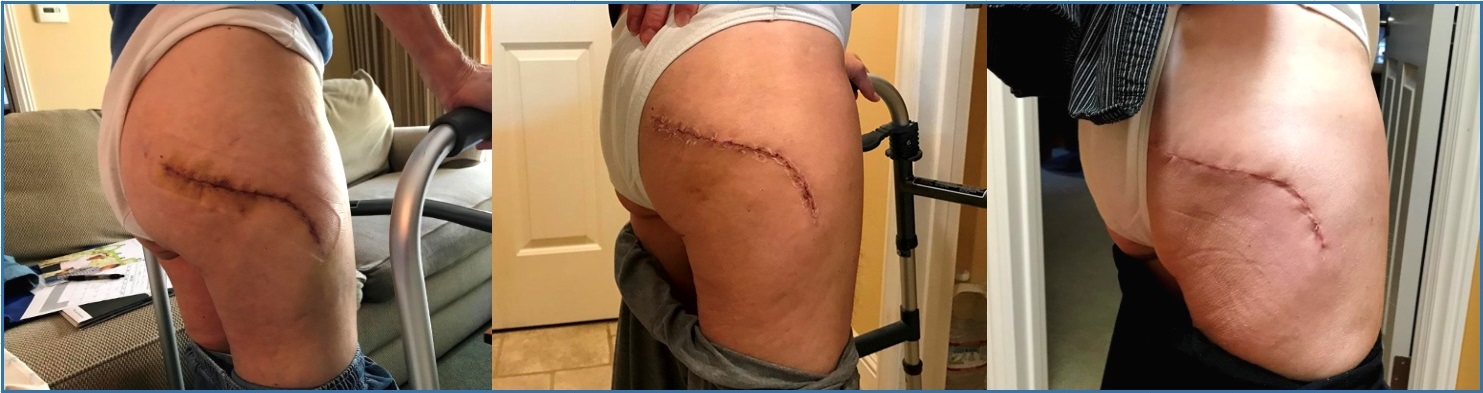
My surgical incision on Day 5 (left), Day 17 (center), and Day 28 (right)

When I saw how long my incision was, I was pretty amazed that I didn’t experience more pain, and I could better understand the moderate pain I did experience.  My primary pain medication was Percocet, which consists of the narcotic oxycodone plus acetaminophen.  I was to take up to 2 tablets every 4 hours, as needed.  I had decided in advance that I would take as little as possible, while still adequately controlling my pain.  I just didn’t want to take a narcotic any more than was truly necessary.  I ended up taking only 9 tablets total, the last at the end of Day 4.  After that, on a few occasions I took an acetaminophen tablet in the evening, since I’d found that I was uncomfortable in bed.

But the most uncomfortable part of those early days was sitting on a toilet seat, since there was a weird kind of pressure on the incision, bulging it slightly outward.  I quickly learned that, if I pressed my right hand against something nearby, like a cabinet or doorjamb, I could unweight my hip enough to be more comfortable.

Another uncomfortable aspect of the early days was a common side effect of narcotic medications: constipation.  I had been given two meds to deal with that.  In addition I was drinking MiraLax in a glass of water at least once a day, eating dried apricots, eating cherries, eating yoghurt, and drinking apple juice.  Thankfully, once I got off the narcotics this situation resolved itself.

Yet another side effect of narcotic medications is lightheadedness, for some people.  I had two brief, minor episodes, both upon standing up.  The solution in both cases was simple: head for the nearest chair and sit down for a few minutes.

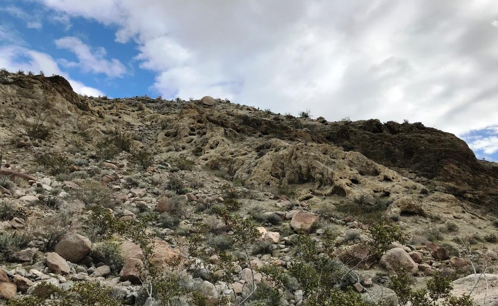
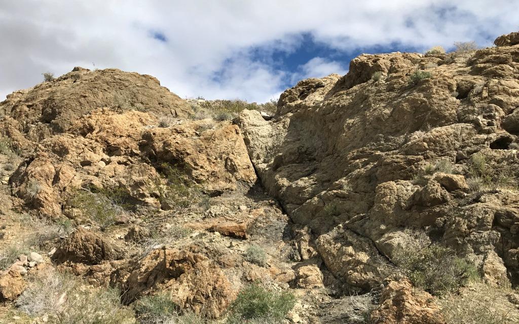
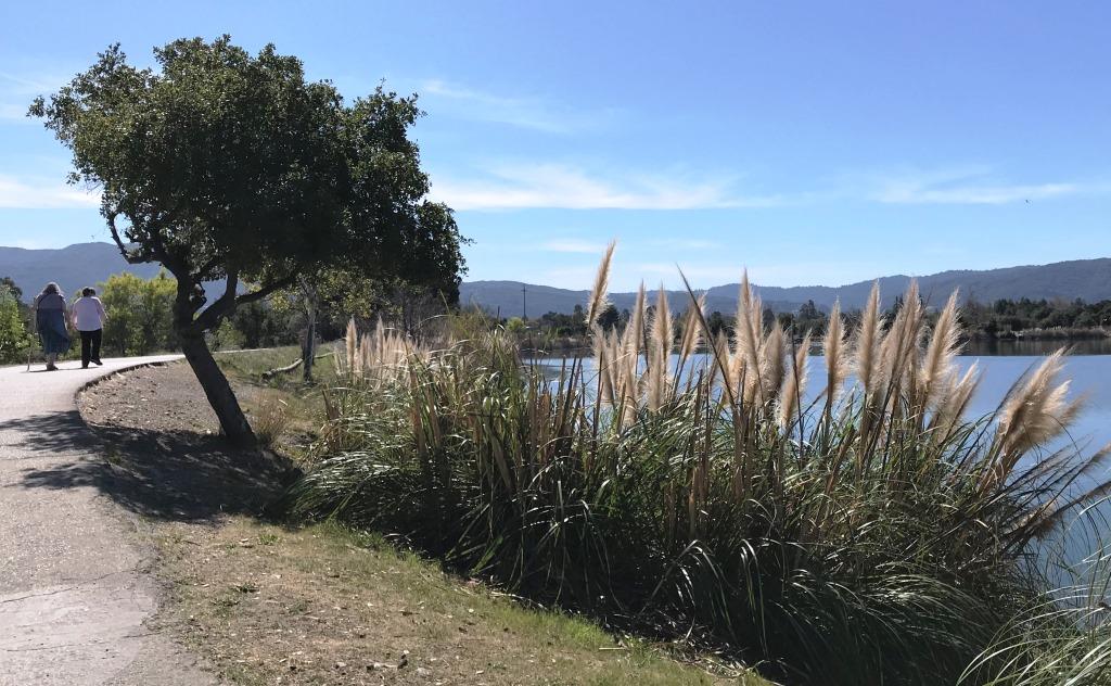
A second accomplishment of the Day 5 PT session was that I was ok’d to walk outdoors.  I had a strong memory of walking outdoors on Day 4 after my repair surgery, and I remembered how wonderful it was to be in my happy place.  This time I only walked out to the sidewalk and then to the far side of the yard, before returning.

photo at the end of my first walk outdoors (Day 5)

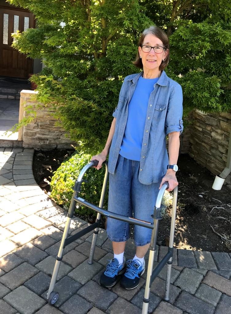
At the end of my first walk outdoors (Day 5)

A complication I had not anticipated was some trouble sleeping.  A couple of nights I’ve had what I consider to be (mild) insomnia: I’d get into bed at, say, 11pm, go through my usual evening reading routine, and still be wide awake.  One night I was restless for an hour and then simply sat back up, turned on a light, and read for another hour.  When I discussed this with my physical therapist, she told me that insomnia is a not-uncommon side effect of orthopedic surgery.  So I have made a point to be kind to myself about this, and I am generally sleeping better as my body becomes more comfortable trying to sleep in my usual positions.

One more minor side effect of the surgery is swelling and bruising in the foot and leg on my surgical (right) side, and this was discussed in my discharge paperwork.  I had swelling in my foot and ankle for a couple of weeks.  One day I tried wearing a compression stocking, but that was too onerous to get on and off, even with my partner’s help, so I focused on elevation.  I found it perversely interesting to pee away some of the retained water in the morning, only to accumulate it again throughout the day.

There was significant swelling around the surgical site. I still ice it every day or two but, per the discharge papers, that may persist for a few months before going away completely.

During my Day 10 PT session, as I was trying out a new exercise for my physical therapist, she noticed that the back of my right calf was bruised.  This is another side effect that I’d read about, but not noticed – it’s not easy to see unless you check while reclining on a couch or easy chair!  There was no discomfort, so I hadn’t thought to check.

photo of bruise on my calf (Day 10)

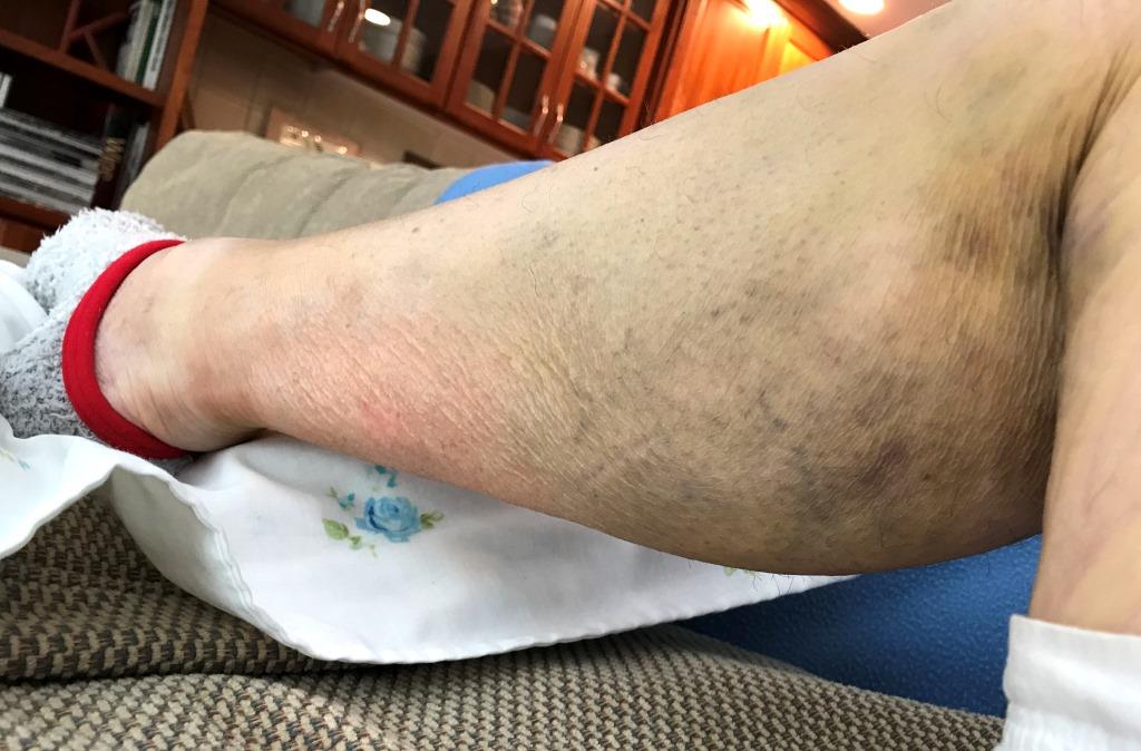
Bruise on my calf (Day 10)

At each semi-weekly PT session I got more, and more challenging, exercises.  The first exercises were mostly isometric, plus one to encourage blood circulation in my legs and feet (and discourage blood clots).  Later I progressed to some strengthening exercises similar to those I’d been doing prior to surgery.  Of course, I could only do mini versions at first.  The surgery had involved cutting several muscles, including the gluteus medius, which is used for adduction (moving the leg out to the side) as well as stability for the entire hip during walking.  Not surprisingly, many of the strengthening exercises target the various gluteus muscles.

Another mechanical area is related to range of motion, particularly bending the hip joint, because I had been impaired for months, if not years, leading up to the surgery.  Strengthening and stretching the iliopsoas muscle, the main hip flexor, will be important in restoring a normal range of motion and walking gait.

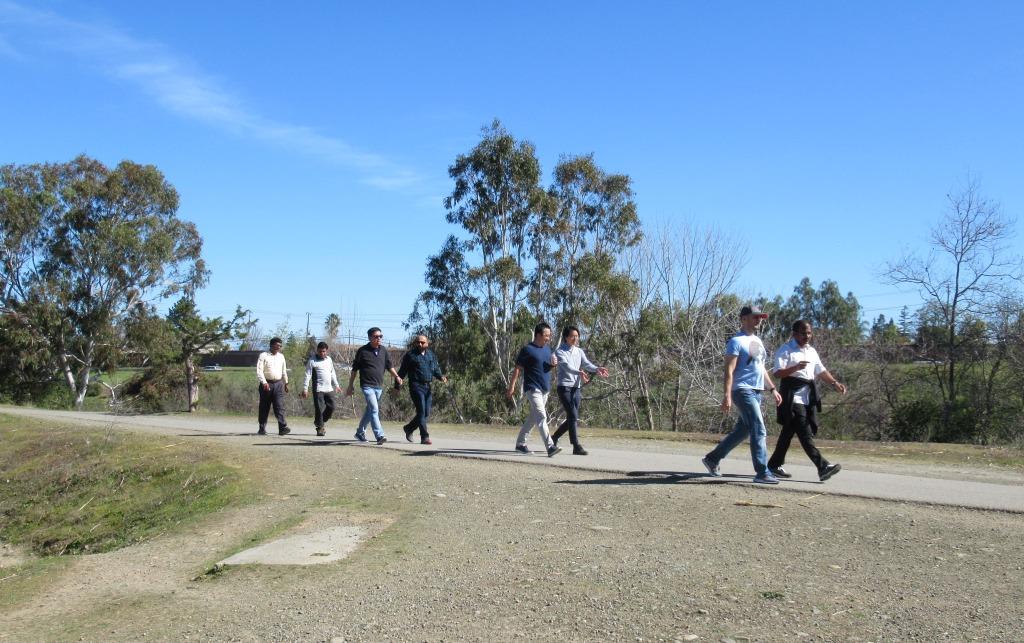
On Day 19 I was discharged from home-based PT to outpatient PT.  By then I was using my cane indoors, though still using the walker outdoors.  The therapist who did my discharge suggested I consider using hiking poles for my outdoor walks, instead of the cane.  I waited a couple of days, just to make sure I felt ready, and then made the transition.  Here I’m returning home at the end of one of my walks on Day 23.

photo of transition to hiking poles for outdoor walks (Day 23)

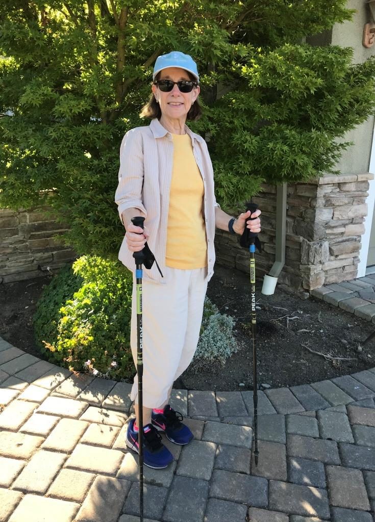
Transition to hiking poles for outdoor walks (Day 23)

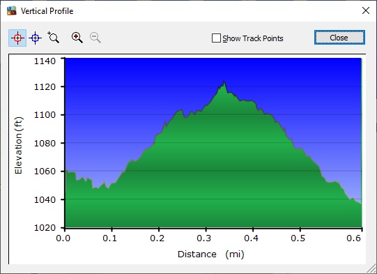
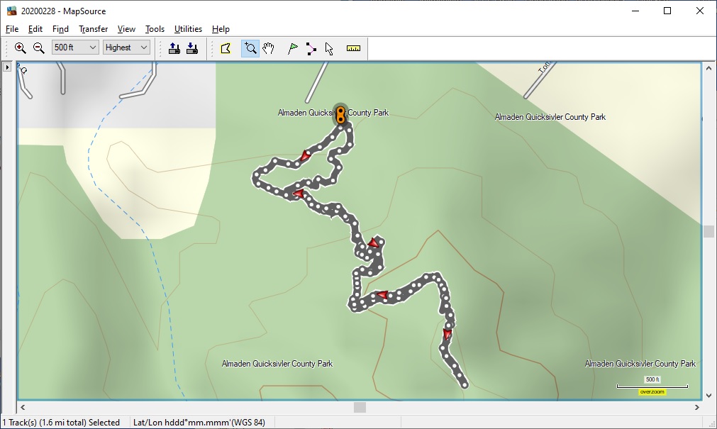
As I write this post I’m on Day 28 of my recovery.  My incision is largely healed (see the photo above); the next step to encourage further healing is scar massage.  Meanwhile my bone is busy attaching itself to the implanted parts, and this bone fixation should take 6-8 weeks.  Muscle and other soft tissue repair will take a bit longer, 10-12 weeks.  By then I will have already begun to return to longer walking sessions and even short hikes.  I’m really looking forward to that! – and hope that shelter-in-place orders for my age group still support outdoor exercise.  Currently I take 2 walks per day and am walking all the way around my small block, around 0.3 mile, on each walk.

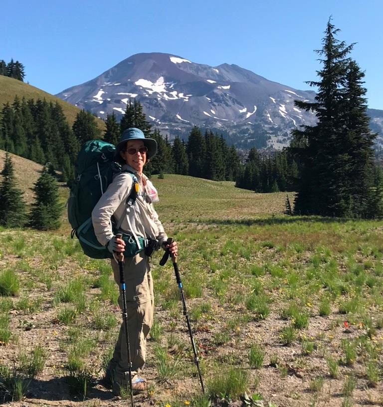
When my hip was repaired I told virtually everyone who treated me that I wanted to be capable of doing another (power walking) marathon – and I did do one two years later.  This time I have told several people who treated me that, almost exactly a year ago, I summited Mt Kilimanjaro, and I’d like to be capable of doing it again – even though I’ll more likely go somewhere I haven’t been yet, just to have a different adventure.

I’m looking forward to continued recovery and plan to write occasional updates along the way.

Posted in hip fracture | Tagged , , | 3 Comments

Waiting Game, Training, and a False Alarm

header

As described in my previous post, I had an exploratory consult with an orthopedic surgeon on December 6, 2019.  During this consult the surgeon told me I was ready for a hip replacement, even though my hip joint was not yet bone-on-bone, because of the severe impairment that I had already experienced to my normal activities.  Once I recovered from my shock over this pronouncement, I was ready to begin to prepare myself.  The earliest available surgery slots would be in March, so I knew there would be a substantial waiting period.

I should mention here that my surgeon also told me that total hip replacement surgery is now an outpatient procedure, so the expectation was that I would go home the same day as the surgery.  Of course, the surgery itself would take place in one of the inpatient operating rooms, rather than an outpatient clinic.  This information barely registered at the time, I was so surprised by the statement that I was ready for the surgery.

Of course, I didn’t – indeed, couldn’t – anticipate how long the waiting period would eventually become: 6 months!

I resolved to remain as active as possible, in order to be in good physical and cardiovascular condition for the surgery.  That meant treating my PT and walking as training, like I had done so many times over the last dozen years.  It was simultaneously familiar and a bit surreal.  I also resolved to be kind to myself: find a level of activity I could maintain consistently, hopefully with minimal pain medication, since I was averse to taking pain meds, even Ibuprofen, daily for multiple months.

An immediate scheduling complication was that I had a trip planned for the first weekend in April.  I would be flying to Lake Placid, NY to watch the 2020 World Synchronized Skating Championships with a friend.  We were both excitedly looking forward to the trip.  Here is an example of a spectacular element that we hoped to see.

image of synchronized death spirals from the 2017 World Synchronized Skating Championships

Synchronized death spirals from the 2017 World Synchronized Skating Championships

I was aware that I would be strongly advised not to travel by airplane, especially cross-country, for 4 to 6 weeks after my surgery, so a March surgery date would not work for me.  I told my surgeon about the trip and asked for a date as soon as possible after my planned return on April 5.  I learned that the surgery schedule was set 2 months out, so the April schedule would be set (and filled) in February.

Meanwhile I continued to work with PT and had one last appointment at the end of December.  After that I didn’t need any new exercises.  The plan was that I would continue what I was already doing, and I had been coached on how to make the exercises more difficult, if desired.  I also shared my perspective on training with my physical therapist.

I developed an exercise routine in December and January, walking about 7 miles a week.  I did 2 hikes during these 2 months, one of which was 4 miles.  That turned out to be the longest hike or walk I did after the orthopedics consult before my surgery – another indication of the decline in the condition of my hip, as well as how I was taking care of myself.

At the beginning of February my local county’s Parks and Recreation Department announced the 2020 edition of a program called PixInParks.   The program consists of 7 hikes, each in a different county park, hiking to a particular location and taking a selfie or group photo; I took a picture of my day pack.  Because of my limited range I decided to do the ADA version of each hike, and I decided to see if I could complete all seven during February.  This was the view at the destination point for one of the hikes.

image of pleasant view on one of my February hikes

Pleasant view on one of my February hikes

Just as I was finishing this series of hikes, on February 27 I received a call with a surgery date: April 21.  My life was about to change, just by answering the phone!  I started a countdown, with just under 8 weeks to go.  In short order I had a pre-op screening phone call, a referral to a pre-op class, and some web pages to read and videos to view.  Within a few days I learned that the pre-op class would be a video event, in deference to the just-emerging local cases of the novel coronavirus.  (On the day I received a surgery date there were 2 cases in my county, and it was about to become an early hot spot.)

I had been hoping to be able to go on a short road trip to southern California to do some spring wildflower viewing and a few short hikes.  After some thought I decided to go for it, and was able to get a container of wipes and a few other supplies to supplement the normal motel room cleaning.  The panic buying of toilet paper, hand sanitizer, and other cleaning supplies was already underway.  I was even able to get a digital thermometer on Amazon, after discovering that one of my local drug stores had been completely bought out by one person who had walked out with $1500 worth of them!

I drove down on March 12 and back on March 17.  It was a good trip, even though it felt odd to be taking some of the precautions I did.  This was in the very early stages of social distancing guidelines.  On the first of two days I spent at Joshua Tree National Park I was pleasantly surprised to run into a fellow student from an intensive California Naturalist training course four years earlier.  We elbow-bumped in greeting, and then I asked his friend to take a picture of us, which he obligingly did.  We got this close together for the picture and then quickly separated again to the recommended 6-foot distance.

image with a fellow California Naturalist course student, at Joshua Tree National Park

With a fellow California Naturalist course student, at Joshua Tree National Park

The next day, March 16, while still in the Joshua Tree NP area, I received a text message from my partner asking me to call him as soon as possible.  By the time I could get through on my phone I had seen the news story on TV about a shelter-in-place order that was to go into effect the following day in seven San Francisco Bay Area counties.  Yikes!  I was 500 miles away and had no idea whether the main roads into the Bay Area were going to have roadblocks or anything like that.  So, instead of taking two days to drive home, I went more directly, skipping most of the additional wildflower sites I had been thinking of visiting.

On my way home I stopped at a grocery store to try to stock up on essentials, but I had to go out again the next day because the store I stopped at had run out of a lot of items by the time I got there at 7pm or so.  Suddenly, with an indefinite shelter-in-place order, which became state-wide a couple of days later, my life changed again, along with everyone else’s.

The European travel ban was announced on the first day of my road trip and went into effect a day later.  New York Governor Cuomo had also announced that all buildings with a capacity of more than 500 people were immediately closed.  With these announcements it was inevitable that my trip to Lake Placid would be cancelled, as the championships could hardly take place with only about 5 teams and no audience in a building that had been ordered closed.  The official cancellation announcement was made on the day that the European travel ban took effect.

The pre-op video class took place as scheduled on March 23.  Although I did not realize it at the time, the shelter-in-place order had immediately suspended all elective surgeries.  On April 3 I received the call that let me know my surgery was officially cancelled.  I figured that it might be 6-8 weeks after elective surgeries resumed before I would get a slot, if they went in more or less the original sequence of patients.

As the shelter-in-place progressed I focused on continuing daily PT and nearly-daily walks.  Most of my walks were between 1 and 2 miles; I found that this was a distance that I could cover on a sustained daily basis without pain meds.  I also found that it was gradually becoming more onerous to change from sitting to standing, or vice versa: it seemed as though I should limber up before changing position.

In late April I was called with some screening questions and, as a result, was placed in a higher-priority category for surgery once elective procedures could be resumed.  Then there was more waiting.  In the meantime I had decided to do some jigsaw puzzles, a pastime I had enjoyed since early elementary school age.  As my waiting time continued, I completed 6 puzzles!

And I kept walking.  Eventually I added up all of the mileage for my outdoor walks and hikes: about 108 miles prior to the shelter-in-place and another 108 miles after the shelter-in-place, the latter entirely in my neighborhood.

Then, suddenly, everything changed again with another phone call.  On May 27 I received a call with a new surgery date: June 5, only 9 days away! This prompted a rush of preparations.  A few things, like taking daily multi-vitamins, needed to stop immediately, since that was supposed to happen 10 days ahead of surgery.  I needed to have an EKG and blood test, so I went to my medical facility – for the first time since the shelter-in-place had changed everything.  I also picked up a surgery preparation kit, which I would need to use the evening before my surgery.  I went to a medical supply store to get a so-called total joint kit, which includes several aids for simple personal tasks.  I later found that the most useful were the sock aid, grabber, and shoe horn.  I set up a stable chair that I could use for dressing, with a table next to it to hold the aids.  I practiced using all of them, with all of the precautions that would be in place after surgery.

image of total joint kit: various aids for dressing, bathing, etc

Total joint kit: various aids for dressing, bathing, etc

I also got a temporary handicapped parking placard, for which I needed to have an application form signed by my surgeon.  I was glad I could get the actual placard at a local AAA office: these offices had just begun to re-open, but the DMV offices statewide were all still closed.  At home I got out, from a closet, the walker and cane I had used after my hip repair surgery and cleaned them both up.  I made a final trip to the grocery store to stock up on nonperishables.

And I created a punch list of items that I needed to remember to do, both before and after surgery.  I have made use of such lists on other occasions, such as before big trips, and have found this to be a convenient tool.

I even managed to re-schedule a routine dental appointment that I had set up for later in June.  My dentist was just re-opening her office after the shut-down, but was able to see me four days before my surgery.

Three days ahead of my surgery I had a COVID-19 nasal swab test, a requirement to make sure I was healthy and would not be a potential infection agent for any staff at the hospital.  People who have had this test have said that it is uncomfortable; I would say that’s an understatement.  I made a point of going for one last walk right before I had the test, because I’d been advised that, after the test, I should go directly home and self-quarantine until my surgery.

I re-viewed the videos related to the surgery.  One of the videos was about what to expect in the days before, and days and weeks after, the surgery.  The other was about the surgery itself.  This picture from the internet shows the parts of a hip implant and how they fit and work together to replace a damaged hip.

image of hip implant parts for total hip replacement

Hip implant parts for total hip replacement

Another thing I did was to make a list of people I wanted to receive a notification once my surgery was complete.  I set this up so that my partner would only need to notify a handful of people, and they would in turn fan out to others.  It was like an old-fashioned phone tree, but via e-mail and text message.

The day before my surgery I did a few loads of laundry so that I would have clean sheets, towels, nightgowns, and several outfits ready to go.  I organized several pillows that I might need both for sleeping and for sitting on the couch with my leg elevated.  I had already cleaned the bathroom and the kitchen, and I ran the dishwasher one last time.  Finally, I gathered the minimum items I would take with me: ID, medical card, credit card, copy of my Advance Care Directive, glasses case, and a small MP3 music player cued to a long playlist of soothing music, all in a small bag I could carry over my shoulders, hands-free.

I was as ready as I could be!  All that remained was the pre-surgery timeline that had been provided to me, plus doing my best to get a good night’s sleep.  In the next post I will describe the final preparation, a little bit about the surgery itself, and the initial recovery.

Posted in hip fracture | Tagged , | 2 Comments

“You’re Ready Now”

header

In my last post I described the joy of my active lifestyle after recovering from a hip fracture several years ago, and the gradually increasing pain in my hip and limitations to my activities that began to creep in.  In this post I will describe the next phase of my journey: taking action to address the limitations and discovering what would happen next, and when.

In early 2019 my primary care physician (PCP) indicated that I had osteoarthritis (OA) in my hip and that I would potentially need a new hip eventually.  My understanding was that everyone has their own journey through this situation, likely depending on overall health, activity level, and perhaps other factors like genetics.

My summer was busy and active: I trekked on Mt Kilimanjaro reaching the 19,341-foot summit at the Roof of Africa; I hiked and backpacked in Oregon, carrying a 25-plus-pound backpack for the backpack sections; and I hiked for about 10 days in Romania.  During the Oregon trip I managed to sprain my left ankle, which cut the hiking short.  In some respects these activities were the culmination of all of the active years since my hip fracture.  In retrospect, they probably accelerated the development of OA in my hip, though I certainly did not anticipate that at the time.

In any case, by the end of the Romania trip in early October I was quite uncomfortable.  The range of motion in my hip was so limited that I had trouble dressing, going up and down stairs, getting in and out of my car, and even sitting down on the toilet.  The latter was the most distressing.

When I got home I knew I was going to have to do something, though I didn’t yet have a plan; I kind of made it up as I went along.  The first step was to rest: hopefully 2 weeks with greatly restricted activity.  I confess that I did do a 10-mile group hike during this time, since it was a one-time opportunity.  But I took at least every other day off, and most walks were 2-3 miles long: quite short for me.  I also resumed doing some of the physical therapy exercises I’d been doing between hiking trips over the summer.  Neither the rest, exercises, nor almost daily Ibuprofen helped – I felt like I was having an extended flare-up.

After barely a week I e-mailed my PCP to request an x-ray for evaluation, and we quickly agreed on a plan: depending on the x-ray results I would next return to physical therapy or go to orthopedics for a consult and further evaluation.  I had the x-ray done the very next day, and the result was moderate joint space narrowing, in other words, moderate OA – but not bone-on-bone.  So I made an appointment with physical therapy two weeks later, basically the first available appointment.  It turned out to be with the same therapist I’d worked with during my recovery from the hip fracture.

During my first appointment I described the issues I was having, and her nearly deadpan reply was that they were the top 4 complaints of hip arthritis patients.  She watched me walk down the hallway and pronounced that I had “the walk” of a hip arthritis patient.  So in those respects there was nothing unusual.  During her evaluation she noted that my right quadriceps muscle was very weak, probably a result of favoring the right leg for so long going up and down stairs (or steep hiking trails).  And I mentioned that, in the processing of hauling myself into my car ever since the Romania trip, I was starting to develop an issue in my right shoulder.

She gave me several exercises, some (like for the quad and shoulder) new, others familiar but with new variations.  Fortunately, these exercises helped fairly quickly, and within about a week I was doing much better with dressing, the car, and the toilet; stairs remained a work in progress for a few more months.

I was grateful to have a level of relief; I wasn’t pain-free, but it felt more manageable, even though I wanted to be able to walk more than I could without pain.  I recalled a conversation I’d had in Oregon with a particular hiking friend, in which we’d discussed my hip.  She suggested that I might want to see an orthopedist just on a consult-type basis, without an agenda or expectation for next steps, but just to better understand the arthritis progression process, a potential timeline, and options.

After my second PT appointment, about five weeks after the first, I asked my PCP for a referral to orthopedics for an exploratory consult, and she immediately approved it.  I got to choose from doctors who had near-term appointments, making sure to select (with an orthopedic advice nurse’s help) a doctor who specialized in hips, or at least joints.  As it turned out, the doctor I selected for my innocent consult had trained first as a mechanical engineer before going into medicine – and, in graduate school, she had designed replacement joints.  I decided I’d made a good choice!

Just a couple of days later, on Friday, December 6, 2019, I had the consult.  I started out describing the activities I’d done earlier in the summer, what I used to be able to do, and how limited I was by then.  She pulled up my x-rays, showed them to me, and stated that my arthritis was actually severe.  She pointed out that there was some texture on the surface of the head of my femur, indicating the beginning of breakdown of the bone structure.

I want to try to illustrate this with a few x-ray images that I found on-line.  First is a normal hip.  Note the amount of space – actually cartilage – between the ball and socket, and that the surface of the ball (head of the femur) looks smooth.

picture of x-ray image of a normal hip

X-ray image of a normal hip

Of course, my hip had been repaired with 3 screws.  The next image shows a (left) hip with 3 screws.  It’s a little more difficult to see the surface of the head of the femur, and the joint space might be a little narrower.  Note that the heads of the screws extend slightly outside the surface of the femur.  When I noticed this on my own x-rays I commented to my surgeon, and he assured me that it was ok, since that part of the bone is covered with a strong, thick layer of muscles.

picture of x-ray image of a hip that has been repaired with 3 screws

X-ray image of a hip that has been repaired with 3 screws

Finally, this is an example of an arthritic hip.  The joint space is much narrower than in the other images, and there is some texture on the surface of the head of the femur.  Some images of arthritic hips also show bone spurs.  My x-ray looked a bit like this one, with the addition of the screws.  Note that there is still some space, which represents cartilage, so this image does not yet represent bone-on-bone.  My understanding had been that hip replacement was generally done only after the patient had reached bone-on-bone, which was said to be quite painful.

picture of x-ray image of an arthritic hip

X-ray image of an arthritic hip

Once the orthopedist had characterized the degree of arthritis as severe and pointed out the bone’s surface texture, I asked the proverbial $64,000 question: how do I know when it’s getting time for a hip replacement?  Mentally I was quite unprepared for her response: “You’re ready now.”

At the time I had only had two surgeries in my life: a tonsillectomy (and adenoidectomy) at the age of 5 and the hip repair surgery just over 8 years prior.  I really didn’t have a choice about either surgery.  My parents, along with their pediatrician, had decided about the first surgery.  And if I hadn’t had the hip repair surgery promptly I would have ended up needing emergency hip replacement surgery.  My view of surgery was essentially that it was a necessary evil – certainly not something to look forward to or to undergo proactively.

So my response was to start crying, and that seemed to be unexpected.  I barely paid attention when she said her earliest surgery slot would be in March (three months away), though once I settled down I surmised that that had, at least potentially, influenced her statement that I was ready.  She also understood how quickly and dramatically my normal activities had been affected, particularly in the 4 months between June and October.  I was grateful that she placed my current situation in the full context of my normal lifestyle and activity level.  When I updated my PCP about the consult session, she agreed that the orthopedist had, indeed, considered my entire situation.

My next task was to decide if I wanted to proceed by requesting to be put on the surgery schedule.  I spent the weekend thinking about it and having discussions with several family members and close friends.  The following Monday morning I e-mailed the orthopedist and told her I had decided I should go ahead and plan for the surgery.  And so she became my surgeon.

The next stage of my journey was a waiting game, along with developing a strategy to prepare as well as possible for total hip replacement surgery.

Posted in hip fracture | Tagged , , | 2 Comments

An Active Lifestyle with Growing Limitations

header

My original “real hip experience” began in October, 2011.  I fell while ice skating, landing directly and abruptly on my right hip, resulting in a hairline fracture in the neck of the femur – a classic hip fracture, even if the fall was not the most common type.  As I progressed through my recovery I wrote a series of posts, including two instances in which my doctors (surgeon or his PA, physician’s assistant) figuratively showed me a stop sign as an indication that I was trying to do too much too soon.  Once they explained that my risk of too much activity was a re-fracture, or later a stress fracture, I immediately cut back my activities per their instructions.  During the 3-night hospitalization I had told everyone who treated me that I had just completed a (walking) marathon and I wanted to be capable of doing another one sometime after my recovery.  The last post was written a little over 11 months after my injury, and I proudly declared “I’m all better now.”  Indeed, by that time I had completed two half marathons since the injury.

In this post I want to describe, in summary fashion, the active lifestyle I was grateful to be able to return to, and to enjoy for several years.  I also want to acknowledge that I began to develop limitations resulting from the 2011 injury, and I want to describe how those limitations affected me – and how I persevered as well as I could, for as long as I could.  Although I didn’t mention this in the previous set of posts, my surgeon had told me that there was a chance I would develop arthritis in the injured/pinned hip.  I have decided to call it PTOA, post traumatic osteoarthritis, since the injury is considered to be a trauma.  In general, if there is no traumatic injury involved, when a person develops OA in one hip it is frequently followed – if not accompanied – by OA in the other hip.  In my case, because of my fracture, only one hip has been involved.

My active lifestyle has included four main areas: power walking, ice skating, wildflower hikes (or botanizing), and hiking and backpacking.  In each area I have experienced several years of activities comparable to, or even exceeding, my pre-injury levels, followed by limitations and coping.

Power walking: As I mentioned above, I had told everyone who treated my fracture that I hoped to be able to complete another full marathon at some point after my recovery was complete.  In addition, I was keeping track of my times for all timed events I entered: full marathons, a few 10k’s, annual half marathons, and Bay to Breakers (a 12k event).  I have all of this data in a spreadsheet.  I didn’t keep track of 5k’s.

I did complete one full marathon after my hip fracture, my third.  It was the same event (Nike Women’s Marathon in San Francisco) as the one right before my injury, so the same route, two years later.  I trained diligently for it and was thrilled to finish in 5:54:42 (hr:min:sec), setting a new personal record (PR) by almost 6 1/2 minutes.  This is the last full marathon I have done and, in all likelihood, I won’t do another.  The training is really quite demanding.

I have done 13 half marathons, according to my spreadsheet.  Although one was overseas (Dublin, Ireland, in 2014) the rest were local, mostly the San Jose Rock and Roll (SJ RnR) half marathon.  My best half marathon time was the 2014 SJ RnR, with a per-mile time about 30 seconds faster than my full marathon PR.  The next year I bailed and did the 10k, since I had just returned from a month of hiking in Europe and I thought I might be jet-lagged.  After that I started to slow down, and by 2017 my time had increased by about 5 minutes.  I haven’t done any half marathons since then; again, the training and event are fairly demanding on a deteriorating hip.

photo of the start of the 2017 RnR SJ half marathon, with a friend

At the start of the 2017 RnR SJ half marathon, with a friend

My 10k events were mostly Turkey Trots along a similar route to the SJ RnR events.  My fastest time per mile for any timed event was the 2016 Turkey Trot.  In 2018 and 2019 I backed off to doing the 5k distance, and was progressively slower.

The last type of timed event I did several times was Bay to Breakers (B2B), which is about 12k.  I participated in 11 B2B events, right up through 2019 (May).  My fastest time was in 2016, and by 2019 I had added a whopping 15 minutes to my PR time.  This is a really clear indication that my OA was becoming a significant limitation, particularly for power walking.

Every time I have done a timed event I have tried to train and prepare as well as possible, and to walk as well (and fast) as my body would let me on that particular day.  And I knew that it wasn’t just age, but rather my hip, that was slowing me down.

Wildflower hikes and botanizing: Some of my wildflower hikes were, from an exercise point of view, just regular hikes with the added pleasure of finding and photographing wildflowers.  I began to notice, and get more interested in, native wildflowers around 2014.  Since then I’ve enjoyed wildflowers wherever I’ve hiked: in California, other states, and overseas.  I’ve taken several memorable wildflower-inspired road trips, including Death Valley, Anza-Borrego Desert State Park, Mojave National Preserve, and Joshua Tree National Park, most of the above for the spring blooms.

photo of Kelso Creek monkeyflower, a special find

Kelso Creek monkeyflower, a special find

Some botanizing adventures involve relatively little walking or hiking, but more exercise getting down on my knees or sitting on the ground to take flower pictures.  I gradually learned that I needed to be more deliberate – and selective – about getting down and up repeatedly in a single day.

Ice skating: I have skated for over 35 years and have experienced the positive challenges of learning new skills – and trying to maintain them – both as an individual skater and in groups.  When I broke my hip I had an enforced 6-month absence from the ice.  And when my surgeon ok’d me to skate again, with the admonishment to “be careful” (which meant to avoid falling), I was ecstatic.  I have worn a special garment, informally known as crash pads, every time I have skated since then.

photo of Dull Blades cast, final performanace, 2016

Dull Blades cast, final performanace, 2016

A few years ago my Dull Blades group was retired, but I continued with a weekly group class emphasizing skills.  Gradually, and especially in the last couple of years, it became more difficult for me to maintain skills.  I would attribute much of this decline to age – and lack of sufficient practice! – but some could be attributed to advancing arthritis.  At some point, as my range of motion decreased, I privately acknowledged that if I ever reached the point where I was unable to put my skates on and lace them myself, I would have to stop skating.

Hiking and backpacking: I have had many wonderful and memorable hiking experiences since my hip fracture.  Some of the most memorable were overseas hiking trips: Northern Ireland, the Dolomites, Julian Alps, Patagonia, Hong Kong, and Romania.  Many of these adventures still await attention in my backlog for this blog.

During these years I hiked about 500 miles of the Pacific Crest Trail (PCT) and began to do some backpacking.  In June, 2018, a friend and I did a 25-mile day hike on the PCT, which we referred to as our big-a$$ hike.  In August, 2019, we did an 18-mile day hike on the PCT in Oregon, along with nearly 50 miles of backpacking in shorter stints (but carrying 25-plus-pound packs).

photo of carrying my pack in the Three Sisters Wilderness, OR, August 2019

Carrying my pack in the Three Sisters Wilderness, OR, August 2019

A big highlight was climbing Mt Whitney in August, 2016.  This was a marathon-length (21 miles, 19 hours) hike with 6,000 feet of elevation gain and loss, to the highest elevation I had yet experienced: 14,505 feet, the highest point in the lower 48 states.  After I reached the summit I was so elated that I literally jumped into the air several times while one of my hiking companions took pictures.

photo of celebration at the summit of Mt Whitney, August 2016

Celebration at the summit of Mt Whitney, August 2016

But my proudest hiking accomplishment was summiting Mt Kilimanjaro just last June, 2019.  It was an 8-day supported and catered trek to the Roof of Africa, at 19,341 feet.  While I did have noticeable issues with the elevation, and I did not hike fast, my hip behaved admirably.

photo of at the Roof of Africa, Mt Kilimanjaro, June 2019

At the Roof of Africa, Mt Kilimanjaro, June 2019

I found that hiking was easier on my hip than power walking, so I was able to continue having amazing experiences later in my journey to and through OA.  My most recent hiking trip was in Romania, in September, 2019.  However, by the time I returned from that trip I had relatively severe limitations.

Growing limitations: As hinted in the above descriptions, I was able to return to and continue an active lifestyle after recovering from the hip fracture.  Early in either 2016 or 2017 I mentioned for the first time to my primary care physician (PCP) that I was starting to develop some pain in my right hip.  At first she said she thought it was arthritis and gave me some general hip exercises to do.  I was diligent for a while but found it difficult to stay the course and continue indefinitely to do physical therapy for up to an hour a day.  At a subsequent annual visit, when I mentioned the pain again, she did some range of motion tests and mused that it might actually be bursitis, since I had rather good range of motion – in retrospect, I wonder if that was due to my ongoing level of activity.

At the beginning of 2019 I was recovering from a severe foot injury in my left foot and had been getting PT for that, and my physical therapist pointed out that when I favored my left foot I was transferring poor body mechanics to my right hip, thereby aggravating the hip.  At my 2019 annual visit with my PCP, when we reviewed the situation again, she told me directly that I had OA in the hip, and would potentially need a hip replacement at some point.

Of course I kept this in mind as I completed my preparations for a very busy summer: the Kilimanjaro trip, 2-plus weeks hiking and backpacking in Oregon, and a hiking trip to Romania.  As mentioned, the Kilimanjaro trek went well (and was amazing!).  In Oregon I had an accident and sprained my left ankle, so I had to cut short the backpacking and some more planned hiking.  When I left for Romania I thought the ankle was sufficiently healed, but I really struggled during the trip.  I even skipped altogether one day of hiking – something I’d never done before.

By the time I got home I was in pretty bad shape: I could barely get dressed; going up or down stairs was treacherous; and getting in and out of my car was painful.  But the worst was sitting down onto the toilet.  More than once in Romania I was concerned that I was going to end up on the floor if I mis-aimed my buttocks.

It was time to take action.  The next post describes the next stage of my journey.

Posted in hip fracture | Tagged , , | 3 Comments

Spring in the time of coronavirus

In a recent post I described some of the spring colors I have encountered during my neighborhood walks during this spring’s coronavirus-related shelter-in-place.  In that post I described fairly traditional things that I like to put in my “seasonal colors” posts: flowers, birds, and a few fun things.  I also saw quite a few things that were more specific to the coronavirus pandemic in which we all find ourselves.

So I decided to create a second post more specific to the pandemic, and one day a name suddenly occurred to me for this post: Spring in the time of coronavirus.  The name is a takeoff on Love in the Time of Cholera and is a salute to its author, Gabriel García Márquez.  I was introduced to some of his works, particularly One Hundred Years of Solitude, when I somewhat impulsively took introductory Spanish while studying physics in graduate school, and decided to try to read One Hundred Years of Solitude in Spanish.  The text is rich and complex and, even with lots of help from my Latinoamericano friends, I had to abandon my ambitious project after just a couple of chapters.  But the impression was deep and remains with me still, well over four decades later.

At times it has felt more difficult than usual to find joy in being confined to our houses and immediate neighborhoods.  This post is from approximately 10 weeks into the shelter-in-place.  While many people are beginning to experience fatigue, I am grateful that I’ve been able to take one day at a time and enjoy something in every walk I’ve taken – even if it is just the joy of being able to walk outdoors.

I suspect that many neighborhoods have experienced a surge in chalk drawings on sidewalks, driveways, and even streets.   It has been a great way for children of all ages to create art and express feelings.  Some neighborhoods have even had contests.  Here is one example of a colorful rendition of stained glass windows, drawn in a driveway.  So many variations are possible, and both the colors and the geometric designs seem almost endless.

image of colorful chalk stained glass window

Colorful chalk stained glass window

In other places I found various types of messages.  Here a youngster (I presume) is offering his or her sister on sale.  Of course I presume this was intended to be a joke, though I note that I found it relatively early in the shelter-in-place when many families were still getting used to getting along with each other amid distance learning and working from home.

image of sister on sale

Sister on sale

In my neighborhood there were various clues with messages written on the sidewalk, rather like a treasure hunt.  I didn’t try to follow a sequence, just noticed several messages as I walked past certain locations.  There was even one message in front of my mailbox, though it was not left by any member of my household!

I found a hopscotch-like game drawn in the street on a court (short dead-end street).  With so little traffic it seemed safe to play in the street in this situation.

image of hopscotch-like game

Hopscotch-like game

On a sidewalk just a few houses from mine I found several messages that seemed to honor a beloved family pet who had recently gone to doggie heaven.

image in memory of a pet named Marley

In memory of a pet named Marley

There were a number of yard signs with inspirational messages.  These two signs were back-to-back in one yard.

image of inspirational signs

Inspirational signs

As many families are well aware, plans for 2020 graduations were changed dramatically this year.  It was nice to see signs honoring the local high school’s Class of 2020 in several yards in my neighborhood.

image in honor of the class 2020

In honor of the class 2020

Near a neighborhood elementary school I found a Happiness Fence.  Visitors were encouraged to write something they were grateful for on a tag and attach the tag to the fence.  I think seeing the fence had the desired effect on me: I smiled and thought of a few things I was grateful for, also.

image of happiness fence

Happiness fence

In a few places there were less happy reminders of the pandemic.  I live fairly close to Stevens Creek Trail, a paved multi-use trail, and was disappointed to find a discarded glove at the side of the trail.  The most disappointing thing about this sighting was that, right next to the green sign in the background of the picture, there was a trash receptacle.  As a member of a high-risk group I was not inclined to pick up the glove – I do not carry hand sanitizer on my walks.  It was several days before I noticed that it was gone, and I appreciate whoever did pick it up.

image of discarded glove next to recreational trail

Discarded glove next to recreational trail

As do many other homeowners in my neighborhood, I have a gardener, and he was not allowed to work for several weeks.  I decided to try to show how shaggy the lawn was getting.  And since the weather was getting warm I turned on the sprinkler system.  Fortunately, within about a week or so after I took this picture the restrictions on outdoor workers such as gardeners were lifted, and he came by on the second day it was legal.

image of my lawn was in need of maintenance!

My lawn was in need of maintenance!

Over the course of several weeks I walked along pretty much all of the streets in my neighborhood.  I tried to vary my route frequently enough that I didn’t get bored.  On one walk I noticed this sign, which I had never noticed before, even though I do periodically walk along the street where it was posted.  Whoever designed the sign had a sense of humor! – and it certainly made me smile.

image of parking sign

Parking sign

Special signage has been posted at many parks, open spaces, and trails to remind users of social distancing etiquette.  This sign is courtesy of the National Recreation and Park Association.

image of social distancing sign

Social distancing sign

There are several Little Free Libraries in my neighborhood, and I always enjoy passing them.  One day I happened to pause for a moment to see what was available, and was rather amused to find this title: Dying to See You.  I presume it is a murder mystery, one of my favorite genres.  This was early enough in the shelter-in-place that my mind immediately conjured up a coronavirus-related theme.

image of book title in a Little Free Library

Book title in a Little Free Library

In addition to my regular outdoor walks, like many others I experienced several changes in my usual activities, as stay-at-home activities substituted for in-person social activities.  And, also like many others, I have spent some time doing jigsaw puzzles.  At the beginning of the shelter-in-place I had about a dozen puzzles that I had put together previously, in addition to 4 that I had not.  This is a collection of my “projects,” including three of the new ones and one repeat.

On the left is Girl with a Pearl Earring, showing the Johannes Vermeer painting from circa 1665.  I had seen the painting at an exhibit at the DeYoung Museum in San Francisco, and I had read the Tracy Chevalier novel after learning that she was a fellow alumna of Oberlin College.  I found the black background to be challenging.

Next is an Amish quilt, also from an exhibit at the DeYoung Museum.  I liked the geometry and the variety of similar and not-so-similar colors.  The quilt’s maker is unknown, though the quilt dates from around 1935 and was created in Holmes County, Ohio.  The name of the pattern is Tumbling Blocks, Stairway to Heaven (variation).  This puzzle has 1,000 pieces (the most common size seems to be 500 pieces).

The third one is entitled Rookery Above the Bay and is based on a photograph by Thomas D Mangelsen.  The puzzle has 750 pieces.  It shows a group of crested penguins, possibly Macaroni penguins (Eudyptes chrysolophus), which are native to the subantarctic region to the Antarctic Peninsula.  I have been lucky enough to see a few species of penguin in the wild and, like many others, I am charmed by them.

The last one is, perhaps obviously, a stained glass window.  The box contains no documentation at all – no title, number of pieces, or manufacturer.  After completing the puzzle (this is the one I had done previously; I think it dates from what I call my “stained glass window period” around 40 years ago) I did some research to see if I could identify it.  I have made a tentative identification: the north rose window at Notre Dame Cathedral in Paris, dating from around 1250.  Many rose windows are based on a symmetry of 12, for the apostles, but this one is based on 16.  The colors look slightly different from the one photo I could find on-line, but I expect that the colors are greatly affected by the daylight at the time of the photo.  The puzzle is certainly based on a photo of not-so-recent provenance, since the image on the puzzle pieces is visibly grainy.  This puzzle was a challenge to assemble, due to the repeating geometry and overall dark colors.  It is likely that I bought the puzzle when I visited Paris in the 1970’s.

image of selected jigsaw puzzles put together during the shelter-in-place

Selected jigsaw puzzles put together during the shelter-in-place

Over the years I have tended to prefer puzzles that depict works of art: I own several Monets, as well as a few Van Goghs, Gaugin, and Renoir.  The last puzzle that is waiting for me to gather the courage start is a 2,000-piece view of Cinque Terre, Italy, which I visited in 2015.

As coronavirus-related restrictions slowly begin to ease, our lives are once again changing.   In my case, it will make it possible for me to have a deferred total hip replacement surgery.  I plan to write about that later.

Posted in Santa Clara County, seasons | Tagged | 1 Comment

Spring colors in the San Francisco Bay Area

A few years ago I began what turned out to be an occasional series of seasonal colors posts (see, for example here).  One recent day during my nearly-daily walk in my neighborhood, I rather literally stopped to smell some roses in someone’s front yard, and I decided on the spot that it would be a good time to write a post about spring colors in the Bay Area.

As has been the case for other “seasons” posts, this one does not describe a single walk, but rather is a collection of observations from several walks.  In this case the walks were all in my neighborhood, in the time since the local shelter-in-place took effect in mid-March.  Most of the sightings I want to share are garden flowers and trees, but there are also several others that are colorful and/or just plain fun.

First I want to describe spring in the San Francisco Bay Area.  Meteorologically, spring typically begins sometime in February, when the earliest wildflowers begin to bloom.  In fact, this year I participated in the fourth consecutive year of a program sponsored by Santa Clara County Parks, called PixInParks.  I completed the ADA version of all seven hikes during the month of February – see here for example – and observed several types of wildflower on most of the hikes.  Because of travel restrictions I haven’t gone on a hike during the shelter-in-place, just walks in my neighborhood.

In the more urban parts of the Bay Area, spring is marked by flowering trees and shrubs as well as numerous garden flowers.  Since the inspiration for this post was stopping during a walk to smell and enjoy some roses, I thought I would start with a picture of a rose in someone’s front yard, right next to the sidewalk.  This one was an especially beautiful color, but I have observed quite a rainbow, from white to pink to red to peach to yellow.  This one was fragrant, too!

picture of beautiful rose in a neighborhood front yard

Beautiful rose in a neighborhood front yard

Not far from my house there is a relatively new subdivision, and the landscaping in front of many of the houses includes this pretty lily, whose name I don’t know.  I discovered that, if you look directly at a fully open blossom from the right viewing angle, it looks a lot like a face.  I think this impression is supported by the position of an inner layer of flower parts that happen to obscure some of the dots near the darker spots on the lower petals (actually, probably sepals).  To me the face looks a little surprised.

picture of lily whose open blossom resembles a face

Lily whose open blossom resembles a face

Some landscaping includes juxtapositions of different-colored flowers, such as this pretty purple-yellow combination.  In this picture, the green foliage is yet something else, with the main flower stem possibly cut or eaten.

picture of purple-yellow-green combination

Purple-yellow-green combination

A spectacular cultivated flower found in landscapes throughout the Bay Area is bird of paradise (Strelitzia reginae), which is a native of South Africa.

pictgure of spectacular bird of paradise

Spectacular bird of paradise

I also found some honeysuckle that I presume to be Japanese honeysuckle (Lonicera japonica), a native vine of East Asia that has been introduced in many areas of the US as an ornamental plant.  It is considered by some botanists as invasive, since it grows quickly enough to choke out native plants.  That’s too bad, since it is so pretty.  Note that the blossoms tend to occur in pairs.

picture of Japanese honeysuckle

Japanese honeysuckle

Finally I’ll note an attractive shrub that I found in a few yards in my neighborhood.  It certainly reminds me of bottlebrush (Callistemon sp), a genus of shrubs endemic to Australia but with some ornamental types in the US, specifically in the San Francisco Bay Area.  Upon further research, I think it is a cultivar with a common name of “little john”, or dwarf bottlebrush.  The ones I saw were about 1 meter high and wide, though presumably pruned to maintain that size and shape.

picture of dwarf bottlebrush

Dwarf bottlebrush

About a half mile from my house there is an access point to the Stevens Creek Trail, a paved multi-use trail that currently extends continuously from the edge of San Francisco Bay for approximately 4.9 miles along Stevens Creek, currently passing through Mountain View.  An additional trail section (see here for more information) is in Cupertino, with plans to connect them.

Along the section between El Camino and Dale/Heatherstone there is a nice variety of mostly native wildflowers, shrubs, and trees, many with identifying signage.  One of my favorites is hummingbird sage (Salvia spathacea), a shrub with distinct nearly-spherical flower heads dispersed along the main stems and with beautiful red blossoms.

picture of hummingbird sage along Stevens Creek Trail

Hummingbird sage along Stevens Creek Trail

These are just a few examples of flowering plants that I particularly appreciated seeing in my neighborhood.  Of course there were many more, including shrubs such as star jasmine (Trachelospermum jasminoides, native to eastern and southeastern Asia) and bougainvillea (a genus of familiar ornamental vines native to South America), shown in the banner photo for this post, lantana, day lilies, and native California poppies (Eschscholzia californica).

I have been somewhat surprised to notice more bird activity than I have previously been aware of in the midst of Bay Area suburbia.  Though I rarely stop long enough to investigate the songs or calls, sometimes the avian residents emerge from the vegetation long enough for clear viewing.  That was the case for a pair of dark-eyed juncos (Junco hyemalis), on the West coast also known as Oregon juncos.  These pretty sparrows are found all across the US, though in different color variations, and are distinguished by their narrow, pink bills and white outer tail feathers that flash when they flit from place to place.

picture of dark-eyed junco

Dark-eyed junco

In addition to flora and fauna I encountered several human-made artifacts during my spring walks, and these also provided visual pleasure during my walks.  Of course some yards contain different types of play structures for children: swing sets, tree swings, tree houses, and so on.  A somewhat unusual structure was a climbing wall that seemed to be just the right size for perhaps a 5 or 6 year old.

picture of colorful climbing wall

Colorful climbing wall

In another yard, in a corner between the sidewalk and driveway, I found a carefully arranged display of colorfully painted river rocks, so called because they have been worn and rounded by the action of moving water, most often in stream beds or on beaches.  The rocks in the display had evidently been selected to have similar sizes and had been painted with a variety of nature-related images.

picture of display of painted river rocks

Display of painted river rocks

There are several yards in the neighborhood with what I usually call pinwheels.  More precisely they are whirligigs, a form of kinetic garden ornament.  Any breeze causes them to spin, and they typically can rotate on the stake to face the wind.  This one caught my attention because it was particularly colorful, and I liked that it had three layers.  Note that the components of each layer overlap in the opposite sense to the neighboring layer.  This meant that the middle layer spun in the opposite direction to the front and back layers.  It was fun to pause and just watch it spin!

picture of colorful whirligig

Colorful whirligig

There are several Little Free Libraries (LFL) in my neighborhood.  A motto associated with LFLs is “take a book, leave a book”.  The motto and the name pretty much tell the story.  Since I had my first encounter with a LFL I have been charmed by them, and I appreciate each and every one I discover.  That first one was in an unexpected place, along a paved multi-use trail outside Madison, Wisconsin, and had a park bench for sitting as well as several potted plants.  This one is more typical.

picture of Little Free Library in my neighborhood

Little Free Library in my neighborhood

I certainly appreciate discovering colorful sights in my neighborhood that I can enjoy in different seasons.  Who knows what I’ll find next?

Posted in Santa Clara County, seasons | Tagged , | 1 Comment

Anza-Borrego Desert State Park: Narrows Earth Trail

stats box

On the first day of a recent road trip to view wildflowers in the Southern California desert, not counting an initial travel day, I visited the North Algodones Dunes Wilderness.  Because I spent less time there than I’d planned, I had time in the afternoon to make a visit in the heart of Anza-Borrego Desert State Park along CA-78 and do two short hikes.  This post describes the first hike, along a self-guided nature trail called Narrows Earth Trail.

On my way to the park from Algodones Dunes I noted some apricot mallow (Sphaeralcea ambigua) along the road side.  A bit later I drove past my two-night home base in Ocotillo Wells, just outside the state park.  As it turns out, there is a small airport owned and managed by San Diego County, the Ocotillo Airport.  It is located on an old lake bed, which is naturally very flat, and has two unpaved runways used only by very small aircraft.  The previous day there had been a rain storm, turning the usually-dry lake bed into an actual, though shallow, lake.  This picture shows the reflection of a hill in the airport-lake.  The hill is in the adjacent Ocotillo Wells State Vehicular Recreation Area.  If you click on the picture to enlarge it, you should be able to see an orange wind sock next to the runways.  Although I expect that the airport floods after every substantial rain storm, I’ve been there several times and not seen it like this, so it was a bit of a novelty.

image of Ocotillo Airport after a rain storm

Ocotillo Airport after a rain storm

After passing the airport I continued driving west on CA-78 for several more miles, entering the park shortly after the airport.  For a mile or so, the highway passes close to San Felipe Creek/Wash in a relatively narrow space between Yaqui Ridge and the Vallecito Mountains.  I think this area is known as The Narrows, and the Narrows Earth Trail is in the western part of this area, about 4 miles west of Borrego Springs Rd.  A parking area is on the south side of the highway near mile 81.5.

Before I found the correct parking area I pulled off the road a couple of times to check my park map.  One of those places may have been at Nude Wash.  In any case, I had a preview of a couple of wildflowers I would see more of, later, on Narrows Earth Trail.  One was desert dandelion (Malacothrix glabrata), which is widespread and common in dry areas of San Diego, Riverside, San Bernadino, Inyo, Kern, and Los Angeles Counties.

image of desert dandelion

Desert dandelion

Another was Fremont pincushion (Chaenactis fremontii), found across a similar swath of Southern California.  These two plants are frequently found together, as shown in the banner picture for this post.

image of Fremont pincushion

Fremont pincushion

Once I found the correct parking area I was ready to begin my short hike.  This Google Earth overview shows both the Narrows Earth Trail and the Quartz Vein Wash, which I explored right afterward.  A sign at the parking area directs visitors to the left, parallel to the highway, for a very short distance to the beginning of the trail.  My hike was just over 0.6 mile, with a slightly different return path along the wash, which is called Powder Dump Wash, named by road-building crews in the 1930’s.

GPS track

GPS track

The elevation profile is almost not worth showing, since the elevation gain and loss were only about 70 feet.  As is the case for many washes that go into a hilly area, the outbound section was (slightly) uphill, with the return (slightly) downhill.

Elevation profile

Elevation profile

There are 7 numbered posts along the trail, and a small brochure available online or in the park Visitor Center describes what you see at each post.  This nature trail focuses on geology, which is often tricky to photograph although the feature of interest can be quite clear when looking at it live.  I stopped at each post, though I only show the feature in a couple of cases below.

After a short distance I came to a very nice chuparosa (Justicia californica) shrub in bloom.  Chuparosa is mainly found in San Diego and Riverside Counties.  It’s somewhat tricky to photograph since, if there are blossoms at all, there are typically lots of them with only a few actually in focus.  It is thought that the name chuparosa comes from the Mexican Spanish word chuparrosa (note slightly different spelling), which means hummingbird. In some areas of its range, chuparosa is an important food source for hummingbirds during their migration.

image of chuparosa

Chuparosa

Soon after that I found my first barrel cactus (Ferocactus cylindraceus), or desert barrel cactus, the small one on the left in this image.  I found the slightly larger one on the right a bit later.  Some barrel cacti grow to a height of several feet, and they are often found some distance away from trails.  These were right next to the trail.  Within California barrel cacti are mainly found in San Diego, Riverside, and San Bernadino Counties.

image of barrel cacti: a small one (left) and slightly larger one (right)

Barrel cacti: a small one (left) and slightly larger one (right)

The first barrel cactus was close to the post numbered 3, which denoted an area with older, softer sedimentary rock next to younger, harder, granitic rock.  Earthquake faults and their associated seismic activity caused these types of rocks to end up near each other, even though they have quite different ages.  The removal of softer material by wind and rain resulted in the small cave-like holes.  There is kind of a line of so-called holey rocks on this hillside, from the upper left to the lower right.

image of holey rocks indicating juxtaposition of softer and harder rock

Holey rocks indicating juxtaposition of softer and harder rock

A few minutes later I noticed a small, solitary Bigelow’s monkeyflower (Diplacus bigelovii).  The blossoms are about 1/2” across, and this plant was only about 1” tall.  They are fairly common in desert washes and are found in the Southern California desert areas from Inyo and Kern Counties to the Mexican border.

image of Bigelow’s monkeyflower

Bigelow’s monkeyflower

The next hillside was marked by another numbered post and a prominent crack, which was identified in the brochure as a fault – one of many in the seismically active area.

image of easy-to-see fault

Easy-to-see fault

Frequently when I hike up washes I end up turning around at a dry fall – a waterfall without any water.  In desert settings a dry fall can suddenly become a waterfall after a rain storm.  Because of the recent rain there was a small puddle at the base of a small dry fall, and it was an easy decision to turn around rather than try to continue.  However, I was glad I had not turned around sooner, because there was a pretty Arizona lupine (Lupinus arizonicus) plant.  Arizona lupine is found in San Diego, Imperial, Riverside, and San Bernadino Counties and has more of a purple color than many other lupines.

image of Arizona lupine

Arizona lupine

The second barrel cactus pictured above was along the upper part of the wash.  And so were a few other Bigelow’s monkeyflowers.  These plants were taller, with more leaves along the stem and with multiple blossoms and/or buds at the top of the plant.  I wondered if the size of the plant might be related to the amount of water, as it seemed likely that the plants farther up the wash, where there was a better-defined and narrow channel, would experience more moisture than plants in a wider area of the wash at lower elevation.  This is kind of a speculation.

image of Bigelow’s monkeyflower

Bigelow’s monkeyflower

Soon, as I followed the trail down the wash, the return path diverged from the outbound path.  In this area I found several cacti.  First was a pencil cactus (Cylindropuntia ramosissima), which has distinct branches and spines.  The branches are very skinny, resembling pencils, and the spines are rather long, a few times the branch diameter in length.  Click on this picture to enlarge it and see the spines.  Pencil cactus is found in the four main Southern California desert counties: San Diego, Imperial, Riverside, and San Bernadino.

image of pencil cactus

Pencil cactus

Nearby I found a pair of similar, but different, cacti growing next to each other.  At first I thought the one in the back was another pencil cactus, but the spines are both shorter and more numerous.  In addition, there is less branching at the tips of the branches.  I am not sure of the identification, though it is certainly related (Cylindropuntia sp).  The cactus in front is most likely Gander’s cholla (Cylindropuntia ganderi), which is one of the most prevalent cacti in Anza-Borrego Desert State Park.  The branches have a larger diameter than the (possible) pencil cactus, and the spines are more prominent and numerous, especially at the tips of the branches.  Gander’s cholla is found in San Diego and Riverside Counties.

image of possible pencil cactus (back) and Gander’s cholla (front)

Possible pencil cactus (back) and Gander’s cholla (front)

As I descended Powder Dump Wash I had a nice view of the informal trail through the desert chaparral and some dramatically side-illuminated clouds against an intense blue sky.

image of Powder Dump Wash

Powder Dump Wash

I passed one or two ocotillo (Fouquieria splendens) plants with just a few blooms.  Then I found a desert agave (Agave deserti) with a spectacular spent flower stalk.  The large, prominent bracts made the flower stalk look a bit like a giant asparagus stalk.  Desert agaves, sometimes called century plants, may grow for up to 20 years before blooming once, dying, and then slowly decaying over a period of years.  They are found in western San Diego and southern Riverside Counties.

image of desert agave

Desert agave

When I arrived back near the trailhead I stopped to look more carefully at some pretty phacelias that I’d seen several times along the trail.  I believe they are common phacelias (Phacelia distans), one of the more common and widespread species among the approximately 47 phacelia species found in San Diego County.

image of common phacelia

Common phacelia

This short hike turned out to be a nice combination geology and wildflower walk.  When I finished I still had some more time, so I went to another nearby (perhaps 0.1 mile away) trailhead to explore Quartz Vein Wash.

Posted in San Diego County, Southern California desert, wildflower hikes | Tagged , , , | Leave a comment

Algodones Dunes exploration

stats box

During the second week of March – just before what turned out to be a critical period in all of our lives – I finalized my plans to take a short road trip to the southern California deserts to view some spring wildflowers.  At the time I was primarily focused on the timing of upcoming total hip replacement surgery and secondarily on the emerging novel coronavirus crisis.  With some effort I was able to stock up on a few cleaning items that I wanted to take with me and that were in increasingly scarce supply in stores, like wipes and paper towels, while cognizant that I’d need to be able to make do with the modest supply of hand sanitizer I had available.

In any case, I made motel reservations for 5 nights – 2 in Ocotillo Wells, 1 in Indio, and 2 in Twentynine Palms – and set out from home in the Bay Area with maps, guide books, wildflower books, and a rough plan.  I was aware that there was a good chance for some rain in the southern desert area on my travel day, but hoped that that wouldn’t negatively affect the trip.

This turned into an interesting reminder about desert rain storms the next morning.  My motel was not far from the Ocotillo Airport, a small San Diego County-owned aviation facility with two unpaved runways.  The airport is located on a dry lake bed – that is, the lake bed is dry except after rain storms.  This is a view from the local highway, CA-78.  Sure enough, just as we learned in our childhoods, water collects in local low points, in this case the lake bed which was surrounded by a modest berm.

picture of Ocotillo Airport after a rain storm

Ocotillo Airport after a rain storm

The desert air was clear, with views toward some of the mountains in Anza-Borrego Desert State Park which I would visit later that afternoon and the next day.

picture of view across the desert toward Anza-Borrego Desert State Park

View across the desert toward Anza-Borrego Desert State Park

My objective for the day was to drive to the Algodones Dunes area in southeastern Imperial County, enjoy the dunes, and botanize.  The Algodones Dunes area has two main sections, divided by CA-78, the same highway on which my motel was located.  The north section is the North Algodones Dunes Wilderness, which is about 26,000 acres or 40 square miles in area.  According to the web site, the designated Wilderness also includes the Imperial Sand Hills National Natural Landmark and the Algodones Outstanding Natural Area, though I didn’t find descriptions of these areas.  The section south of CA-78 is the Imperial Sand Dunes Recreation Area, which is about 82,000 acres or 128 square miles in area.  It extends to the Mexican border and is the largest sand dunes area open to off-highway vehicle use in the US.  Because there are a number of plant and insect species that are endemic to the area, this situation has given rise to some tension between ecological and recreation use proponents.

I was hoping to visit the North Algodones Dunes Wilderness.  Because of the wilderness designation there are roads only along two sides, and in order to visit it is necessary to park in one of three nearby parking areas and walk in.  The parking area I was hoping to reach turned out to be inaccessible in my Prius, since it is located about 2 miles along a road that is more like a sand wash, reached by driving down a steep sand embankment.  I was sure that, even if I reached the road, I would not be able to drive back up the embankment after my exploration.  So I (wisely) abandoned my original plan and went to Plan B: I would go to an overlook, reachable by a short paved road, and explore from there.

The overlook is the Hugh Osborne Scenic Overlook, and it is just south of CA-78 about 4 miles west of the tiny town of Glamis.   Though I did not realize it at the time, the overlook parking area is a legal access point for the North Algodones Dunes Wilderness, since one can park there, walk down the access road to CA-78, and cross the highway into the wilderness area.  I decided to simply explore a smaller area of the dunes close to the parking area.  I discovered that most of the parking spaces were occupied by ATV users, since the overlook is technically in the OVH recreation area.

Looking roughly south, away from CA-78 and into the dune area, the myriad of ATV tracks dominate the landscape.  On the one hand my first impression was disappointment about all of the tracks in this natural area.  On the other hand, the Imperial Sand Dunes Recreation Area has been specifically set aside precisely for this use, and the area is owned and managed by the federal Bureau of Land Management (BLM).

picture of ATV tracks in the Imperial Sand Dunes Recreation Area

ATV tracks in the Imperial Sand Dunes Recreation Area

I parked in a Day Use parking spot and prepared to do a short hike.  Basically I walked past a few large RV’s to the far end of the paved parking area and set out into the dunes, away from the busy ATV area.  I made a small loop, just 0.6 mile and about 40 minutes total, as shown in this Google Earth image of my GPS track.

GPS track

GPS track

The elevation profile shows the relatively modest elevation changes, about 160 feet total.

Elevation profile

Elevation profile

First I headed for a nearby dune top, where I had a good view to the north, across CA-78 and into the North Algodones Dunes Wilderness.  This turned out to be the highest elevation of my hike.  The dark spots in the picture are plants, which seemed to be more prevalent in the Wilderness than in the Recreation Area.

picture of view across CA-78 into the North Algodones Dunes Wilderness

View across CA-78 into the North Algodones Dunes Wilderness

I continued generally straight ahead, west, to the next dune.  Of course that meant going down the first dune, about 60 feet, and then up the next one, about 45 feet.  And it should be clear from the pictures that the sand was very deep and fairly loose.  Actually, because of the previous day’s rain, the sand was somewhat more firm than it sometimes is.  In any case, once I reached the next dune top, which had an interesting curved shape, I decided to see if I could get my hiking poles to balance for a picture.

picture of my hiking poles on a nice, curved dune top

My hiking poles on a nice, curved dune top

I was the only person walking around in that area, and the only marks in the sand were my footsteps, my pole holes, and patterns made by the sand blowing in the breeze.  This view was generally to the east, so the dark hills in the background are probably the Chocolate Mountains, where there is a huge US military gunnery range.

Next I went down the side of the dune to look at a couple of plants, which I was unable to identify.  I climbed up high enough on the side of a dune so that I could kind of traverse for a bit.  Then I had to go down in order to be in position to climb gradually back up to the parking area.  As I was passing parallel to the parking lot pavement, but still out in the sand, I became a bit more aware of the buzzing of numerous ATV’s, and I noticed that I could see several at once, moving in and out of view, in front of or behind mini-dunes.

picture of dunes with several ATV’s buzzing around

Dunes with several ATV’s buzzing around

This is an example of a couple of ATV’s that had been driven to the overlook parking area, perhaps to use the restroom.  Many seem to be fancy, and they all sport fairly large flags on poles, for visibility in the dune landscape.

picture of ATV’s at the Lookout parking area

ATV’s at the Lookout parking area

I should note that, while driving out to the sandy road I decided not to explore, I had noticed quite a few desert plants and flowers along the sides of CA-78.  The road was liberally posted with signs advising that there was no parking within 30 feet of the pavement.  When I found essentially no plants on my hike, I decided I would go back along the road and simply pull way over on the shoulder in a few places, getting out of my car long enough to explore relatively briefly.  I made all of my stops driving west, so technically I was on the Wilderness Area side of the highway when I got out of my car.

In any case, I found several interesting flowers.  First was birdcage evening primrose (Oenothera deltoides deltoides), also called dune evening primrose.  It is found primarily in the Southern California desert counties of Imperial, San Diego, Riverside, and San Bernadino.  There were numerous clusters of them along the side of the highway.  Even though the flowers bloom at night and then die the next day, I found plenty of fully-open flowers at mid-day.

picture of birdcage evening primrose, or dune evening primrose

Birdcage evening primrose, or dune evening primrose

There were also numerous large clusters of desert sand verbena (Abronia villosa villosa), sometimes called hairy sand verbena.  Within California its range is similar to that of birdcage evening primrose.

picture of desert sand verbena, or hairy sand verbena

Desert sand verbena, or hairy sand verbena

Suddenly I noticed a butterfly, motionless on the ground.  I stooped down to check it out, and determined that it was dead.  It was a painted lady (Vanessa cardui).  These pretty butterflies have an annual spring migration from Mexico and the southwestern US deserts to the Pacific Northwest.  The migration takes a few months and requires up to a half dozen successive generations of butterfly.  Females are said to reproduce virtually continuously.  I hoped that this individual had been able to reproduce before dying!

picture of painted lady butterfly next to the highway

Painted lady butterfly next to the highway

At my next stopping point, just a short distance away, I found some giant Spanish needle (Palafoxia arida gigantea).  In contrast to “normal” Spanish needle, the “giant” plants are much taller, generally waist-high or even up to 6 feet tall.  These were closer to waist-high.  Giant Spanish needle is considered to have a California Rare Plant rank of 1B.3 and is found only in the Algodones Dunes area.

picture of giant Spanish needle

Giant Spanish needle

Nearby I found some Algodones Dunes sunflower (Helianthus niveus tephrodes) plants with good populations of cheerful, recognizably sunflower blossoms.  This plant has a California Rare Plant rank of 1B.2 and also is found only in the Algodones Dunes area.  If you click on the picture to enlarge it, you can see that the disc flowers really do look like tiny individual flowers.  I haven’t noticed that before for any type of sunflower, so I thought it was kind of neat.

picture of Algodones Dunes sunflower

Algodones Dunes sunflower

I then moved on to a different location a bit farther along the highway.  I didn’t notice anything particular to stop for, but sometimes when botanizing – especially in a new or unfamiliar area – it can be rewarding to just stop periodically, get out of the car, and simply look around.  Here I noticed a few low-growing plants, about 6” high and 2 feet across.  When I looked more carefully I noticed tiny, delicate flowers with nearly translucent petals.  Later I determined that it was cheesebush (Ambrosia salsola salsola).  When mature, these bushes can be up to 3 feet high.

picture of cheesebush

Cheesebush

Nearby I investigated another low-growing plant, this one with small (less than 1/4” across), deeply grooved leaves.  I didn’t notice any blossoms at the time, but my picture may show a couple.  In the inset, my finger is about 1 cm, or 3/8”, across.  I was unfamiliar with this plant, but was able to identify it later using the “What grows here?” feature on Calflora.  It is fanleaf crinklemat (Tiquilia plicata), and it is found in the same four Southern California desert counties mentioned previously.

picture of fanleaf crinklemat

Fanleaf crinklemat

Continuing west on CA-78, when I reached another side road with a sign indicating a ranger station, I went in to see if it was staffed and, if so, if I could get some more information about the area.  It was the Cahuilla Ranger Station, and the road leads further into the Recreation Area to several campgrounds.  After chatting with a ranger and picking up some information, I parked my car and got out to explore once again, near the highway.  I was excited to find a desert lily (Hesperocallis undulata), a favorite desert wildflower and another resident of the four Southern California desert counties.  As it turned out, this was the only desert lily I saw in 4 days visiting the desert parks.  The blossoms weren’t fully open, but that made it easier to see the characteristic green stripe on the outside of each petal and sepal.

picture of desert lily

Desert lily

I drove farther and then pulled over one more time, when I noticed several bright yellow flowers.  I thought they might be desert gold (Geraea canescence), or desert sunflower, and they were.  I had first seen them a few years ago in Death Valley where, in a good rain year, they literally carpet the valley floor.  Unlike many other sunflowers, the disc flowers are orange rather than brown.  They are always a delightful find.

picture of desert gold, or desert sunflower

Desert gold, or desert sunflower

I also found some cryptantha (Cryptantha sp) plants with not-so-tightly coiled cymes and relatively few blossoms.  I am not at all skilled in distinguishing between the many species of cryptantha, but I will note that narrow-leaved cryptantha (C angustifolia) is one of the more commonly observed species in Imperial County, and it is characterized by long hairs.

picture of cryptantha with striking, long hairs

Cryptantha with striking, long hairs

After deciding that I’d stopped in enough places along the CA-78 highway – especially since parking wasn’t legal – I continued back toward Ocotillo Wells without further stopping and adventures.  But since I’d spent much less time walking in the Algodones Dunes than I’d hoped to, I decided to continue west into Anza-Borrego Desert State Park to explore a couple of short self-guided nature trails, as described in a separate post.

Posted in Imperial County, wildflower hikes | Tagged , , , , | 1 Comment

SCCP PixInParks 2020 (ADA route): Almaden Quicksilver County Park

stats box

During the month of February I have been hiking the trails that were designated for the 2020 PixInParks Challenge, a program sponsored by Santa Clara County Parks.  The program consists of seven easy-to-moderate hikes, each in a different county park, selected to give or introduce participants to a range of experiences.  The idea is that people go for a pleasant outing in one of the parks, hike along a specific trail to a particular location, and take a group picture or selfie – usually there’s a nice view.  You then post the picture on social media with specific hashtags.  It’s a nice way to get out and visit county parks.  This year, due to a temporary issue that limits my walking, I have decided to do the shorter routes suggested for ADA visitors.

This post describes my seventh, and therefore last, PixInParks hike for 2020, in Almaden Quicksilver County Park. I have hiked in Almaden Quicksilver, AQ for short, numerous times from all three major staging areas.  The park is over 4,000 acres in size and has a rich history, particularly including mining activities.  There are numerous mine remnants and other mining artifacts, including a museum and a rotary furnace that is visible from almost halfway across the park.  In the height of the mining era some 1,800 miners and their families lived within the current park boundaries.

The PixInParks hike begins and ends at the Mockingbird Hill staging area in the Almaden Valley.  The short version that I did does not extend to the heart of the park, but there are 37 miles of hiking trails, some also open to bikers and/or equestrians, so there is a lot to see and enjoy on a more extended visit.  It seems that there is always another trail that I haven’t yet hiked!

Almaden Quicksilver is known for having a nice wildflower display in the spring.  I’ve never seen carpets of flowers there, but it seems that there is always a variety of flowers in bloom during the spring.  On the day of my visit near the end of February, I found a nice variety.  Almost before I left the staging area I found my first wildflower: chickweed (Stellaria media).  This is actually a non-native wildflower; it has been naturalized in the wild, which means that it grows and propagates on its own without human encouragement or intervention.  But unlike some other non-natives, it is not considered to be invasive – so it apparently co-exists nicely with native plants.

photo of chickweed near the Mockingbird Hill staging area of Almaden Quicksilver County Park

Chickweed near the Mockingbird Hill staging area of Almaden Quicksilver County Park

Almost immediately I also found some California buttercups (Ranunculus californicus), a California native.

photo of California buttercup

California buttercup

And in the next hundred yards or so I found miner’s lettuce (Claytonia perfoliata), wavy-leaved soap root (Chlorogalum pomeridianum), hound’s tongue (Cynoglossum grande), and some poison oak (Toxicodendron diversilobium).  The poison oak wasn’t blooming, but its leaves-of-three were shiny, as they often are in the early spring.  February is a bit early for many of the flowers and plants I saw, but the growing and blooming seasons often adjust according to the timing and amount of winter rains.

Before continuing the description of my hike, I want to provide an overview.  Here I show my GPS track for the hike, where the orange dot denotes the Mockingbird Hill staging area’s parking area.  The hike was basically an out-and-back hike on the Hacienda Trail, though I took an alternate route on the New Almaden Trail for the final 0.2 mile of the return.  My round-trip distance was 1.6 miles.  The “regular” (non-ADA) PixInParks route was a 4.5-mile loop continuing much farther into the heart of the park.  It would have been beautiful, but is simply beyond my range this season.

GPS track

GPS track

The elevation profile shows that the Hacienda Trail climbs steadily away from the trailhead.  The PixInParks photo location was at the highest point of my hike; as described below, I went a short distance beyond the photo location before beginning my return hike.  The total elevation gain and loss were about 560 feet, mostly to arrive at the viewpoint.  The elevation profile shows that the trail gradually gets steeper; the second half of the climb had an average grade of a little over 15%, which is definitely steep enough to notice.  The average grade for the entire hike was 13%.

Elevation profile

Elevation profile

Almost 1/4 mile from the trailhead Hacienda Trail crosses New Almaden Trail, where the regular route’s main loop returns if the loop is hiked in the clockwise direction.   I continued straight on the Hacienda Trail.  A little way past the junction I came across some purple sanicle (Sanicula bipinnatifida).  The flower heads are delightfully quirky dark purple balls with long reproductive parts extending outward.

photo of purple sanicle

Purple sanicle

In quick succession I passed some blue witch (Solanum umbelliferum), toyon (Heteromeles arbutifolia), California man-root (Marah fabacea), and polypody ferns (Polypodium sp).  Much of AQ is covered in trees, and the Hacienda Trail winds through a variety of vegetation, zigging and zagging to keep the grade reasonable.

photo of Hacienda Trail in Almaden Quicksilver County Park

Hacienda Trail in Almaden Quicksilver County Park

Occasionally there is a small break in the vegetation that reveals a view of the nearby Almaden Valley, here a few hundred feet lower in elevation.

photo of Almaden Valley

Almaden Valley

I found a nice patch of California maidenhair fern (Adiantum jordanii), with characteristic skinny dark stems resembling hair and with fan-shaped leaves.

photo of California maidenhair fern

California maidenhair fern

There was also a patch of milk maids (Cardamine californica) approaching peak bloom, with fully open blossoms and buds on each plant.

photo of milk maids

Milk maids

Through another break in the vegetation there was a nice view, generally southwest, upward into the heart of the park, where Capitancillos Ridge dominates the landscape.

photo of View of Capitancillos Ridge

View of Capitancillos Ridge

I found an amazing oak tree, I presume valley oak (Quercus lobata) since it was clearly a deciduous individual.  I thought the branch structure was rather striking, so I tried taking some pictures looking upward through some of the branches.  The texture of the bark was also beautiful.

photo of valley oak branches

Valley oak branches

Continuing my climb, I passed a number of blue dicks (Dichelostemma capitatum), with tight clusters of light purple blossoms.

photo of blue dicks

Blue dicks

Near the blue dicks there were numerous common fiddlenecks (Amsinckia intermedia), with 1/2 cm diameter blossoms with yellow petals and a red-orange area on each petal.

photo of common fiddleneck

Common fiddleneck

A few minutes later I found some common lomatium, or hog fennel (Lomatium utriculatum). This plant has feathery leaves, visible in the background of this picture, and numerous compact flower heads on varying-length stems radiating from the top of the main stem.

photo of common lomatium, or hog fennel

Common lomatium, or hog fennel

Above 900 feet elevation the trail became somewhat steeper, and I was secretly glad to have an excuse to pause for nice views, from near a high point in the trail, of El Sombroso, a peak in Sierra Azul Open Space Preserve, and Mt Umunhum.

photo of Mt Umunhum

Mt Umunhum

The PixInParks photo location is a bench at the high point in the trail.  When I first approached, another park visitor was sitting on the bench enjoying the view.  I was reluctant to interrupt her solitude, so I continued down the other side of the mini-ridge for 0.1 mile or so, then turned around and began my return back toward the trailhead.  I took my time, stopping to look at more fiddlenecks and other wildflowers.  When I returned some 10 minutes later I finally asked if she would mind stepping away for long enough for me to take my official PixInParks photo – so I explained the PixInParks program to her, and she seemed to appreciate that.  I usually take a picture of my day pack at the designated location; this time I could have asked her to take a picture of me, but I decided to continue my “tradition” of photographing my day pack.  The view of the edge of AQ and the Almaden Valley was beautiful and peaceful.

photo of PixInParks photo for Almaden Quicksilver County Park (ADA route)

PixInParks photo for Almaden Quicksilver County Park (ADA route)

Then I continued downhill and back toward the trailhead.  As sometimes happens, on the return leg of an out-and-back hike I notice different things from on the outbound leg.  In this case I noticed a nice view to the northeast across the lower Santa Clara Valley toward Mt Hamilton, in the Diablo Range. The bright white buildings of Lick Observatory are visible on the top of Mt Hamilton.

photo of Mt Hamilton and Lick Observatory across the Santa Clara Valley

Mt Hamilton and Lick Observatory across the Santa Clara Valley

Part way back along Hacienda Trail I noticed some Pacific sanicle (Sanicula crassicaulis).  At first I thought it might be some more lomatium, but a more detailed study of the flower heads and leaves indicated that it was Pacific sanicle.  Like purple sanicle, the flower heads are compact balls, this time with yellow petals, and again with long reproductive parts.

photo of Pacific sanicle

Pacific sanicle

Farther along I noticed some more ferns, probably polypody (Polypodium sp), and a pretty, early-blooming bay laurel tree (Umbellularia californica).  When I arrived at the New Almaden Trail crossing I decided to descend on the New Almaden Trail, just for something a little different, and shortly I arrived back at the staging area.

I had selected a pleasant late-February day for my outing, and the final PixInParks hike was very enjoyable.  I was glad to see so many early-spring wildflowers.  And I appreciated that County Parks selected photo locations and, in some cases, alternate routes that made it feasible for visitors to participate in, and complete, the challenge in spite of physical limitations.  Most of all, I appreciated the very existence of an entire network of County Parks that are available for the public to enjoy year-round.

Posted in Santa Clara County, South Bay | Tagged , , , , , | Leave a comment

SCCP PixInParks 2020 (ADA route): Los Gatos Creek County Park

stats box

This month I have been participating in the Santa Clara County Parks  2020 PixInParks Challenge, an annual program now in its fourth year.  The program includes seven mostly easy-to-moderate hikes, each in a different county park.  There is an effort to include a variety of different types of park experience, including some less-visited and some more-visited locations.  The idea of the program is that people go for a pleasant outing in a park, take a picture or selfie at a designated location, and post the picture on social media with specific hashtags.  It’s a nice way to get out and visit local parks for enjoyable outings. This year, due to a temporary issue that limits my walking, I have decided to do the shorter routes suggested for ADA visitors.

This post describes my sixth PixInParks hike for this year, at Los Gatos Creek County Park in Los Gatos.  A significant part of the park, with picnic tables and other amenities, is on Dell Ave near San Tomas Expressway.  The Los Gatos Creek Trail extends both north and south of this area for several miles in each direction along Los Gatos Creek and incorporates a paved multi-use trail along the creek and within what might be thought of as a strip park.  The Los Gatos Creek Trail is a regional trail that connects Los Gatos, Campbell, and San Jose.  The strip park is like a riparian oasis within these cities.

The heart of the park, on Dell Ave, includes 5 ponds with perimeter walking trails, as well as public facilities like casting ponds and a dog park.  The ADA hike for PixInParks follows the pond perimeter trails around ponds 1-3, and the regular hike includes and additional out-and-back segment north along the Los Gatos Creek Trail.  Although I have previously walked a long section of the Los Gatos Creek Trail, I had not previously visited the area around the ponds.  The day of my visit was a nice spring day, and I was treated to a variety of views, spring wildflowers, and waterfowl.

As a kind of preview of my walk, almost as soon as I left the parking area I found a pretty patch of pampas grass (Cortaderia selloana).  As with some other non-native plants, even ones that are considered invasive, I find it to be attractive to look at – possibly one reason it was imported in the first place.

image of pampas grass

Pampas grass

As mentioned above, my walk was primarily on the perimeter trails around three of the five ponds.  I decided to use a Google Earth image of my GPS track because it shows details of the area, and clearly shows that the park really is a green oasis within its surroundings.  My track is shown in blue, and the carat and “active log” label are in the parking area where I started and ended my walk.  I intended to traverse a 3-lobed figure 8 pattern, but I found a fence closing off the left (west) side of pond #1 when I got there.  After going around the ponds I extended my walk north past the casting ponds and dog park, almost to an underpass under San Tomas Expressway, where the Los Gatos Creek trail continues north to Campbell and San Jose.  The total distance I walked was 2.5 miles, and there was virtually no elevation gain or loss.

GPS track

GPS track

From the parking area I walked over to the Los Gatos Creek Trail and headed south along the east side of pond #1.  The paved trail is basically on a small levee between Los Gatos Creek and the ponds.  Not far along the trail I encountered a Los Gatos Creek Trail mileage marker indicating 6 miles from the southern end near Lexington Reservoir.

In pond #1 I noticed American coots (Fulica americana) and Canada geese (Branta canadensis) near the trail.  Farther away, closer to the south end of the pond, there was a flock of what appeared to be gulls.  When I zoomed in with my camera, I was able to identify them as California gulls (Larus californicus).  Distinguishing features included the markings on the yellow bills, the shade of grey of the plumage on the back, and the black-with-white-spots on the tips of the wings, clearly visible in this picture.

image of California gulls in pond #1 at Los Gatos Creek County Park

California gulls in pond #1 at Los Gatos Creek County Park

Before long I passed a nice patch of California poppies (Eschscholzia californica) between the trail and the creek.  This picture shows, in shadow, the reproductive flower parts inside the cupped petals, as well as how the more mature plant looks after the petals have fallen off.

image of California poppy

California poppy

When I got to the first side trail between ponds #1 and #2 I turned right to continue my intended figure-8 pattern.  Near the corner there was a nice specimen of toyon (Heteromeles arbutifolia), a shrub with characteristic orange-red berries.  A little farther along I passed some English plantain (Plantago lanceolata).  Even though this is another non-native plant, I think the flower heads have an interesting appearance: the blossoms appear first at the bottom of the head, giving it an appearance reminiscent of a tutu.

image of English plantain

English plantain

Periodically there are concrete benches if visitor wish to sit down as part of their enjoyment of the park.  Many of these benches incorporate interpretive signage provided by the Santa Clara Valley Water District explaining the Camden Groundwater Recharge Ponds and how they fit into the overall local water system.

When I got to the trail between pond #2 and pond #3 I had a pretty view across the pond, with the Santa Cruz Mountains in the background.  It is worth noting that ponds 3, 4, and 5 constitute a wildlife preserve, though I presume that the waterfowl don’t really make this distinction.

image of view across pond #3

View across pond #3

When I got back to the paved trail I turned right to go around pond #3.  In this area I found a pretty flower that I’ve been unable to identify, though I suspect it is non-native, possibly a garden escapee.  Some of its light purple blossoms appear to have a second white flower in their centers.  The red “accents” (either part of the base of the petal, or perhaps bracts) and bright green foliage added to a nice palette of colors.

image of unidentified purple flower

Unidentified purple flower

Nearby there was another non-native flower: Bermuda buttercup (Oxalis pes-caprae).  This plant is quickly becoming invasive — it’s too bad, since the delicate green veins really look pretty against the bright yellow petals.

image of Bermuda buttercup

Bermuda buttercup

A little farther along I found some field marigold (Calendula arvensis), another attractive non-native.  These plants often grow in masses that cover many square meters of area, or even a small field.  The orange flowers are about 1 cm in diameter.

image of field marigold

Field marigold

Near the field marigold there were some lupines (Lupinus sp), though I’m not sure of the species.   This specimen was clearly in the beginning of its blooming phase, since there were numerous buds present for future blooms.  Also, the accent color was white; in many lupines this will turn to a reddish-pink color after pollination, a visual cue to pollinators to go elsewhere.  I enjoy finding wildflowers in various stages of development and bloom as the spring progresses.

image of lupine

Lupine

When I reached the southern end of pond #3 I approached a beautiful western rosebud (Cercis occidentalis) shrub blooming nicely.  This close-up shows two branches covered with delicate pink blossoms.

image of western rosebud at the south end of pond #3

Western rosebud at the south end of pond #3

After completing my circumnavigation of pond #3 I walked a second time along the trail separating ponds #2 and #3.  I noticed several ducks in the water and took some pictures for later study and identification.  Included were some ring-necked ducks (Aythya collaris).  I find this to be an interesting common name, since the most distinguishing characteristic is a ring around the (blue) bill, not the neck.  The picture shows a pair.

image of ring-necked ducks

Ring-necked ducks

As I approached the paved Los Gatos Creek Trail a group of people walked by, possibly on a lunch break and enjoying some two-by-two chatting.  (Note: this was before social distancing measures were announced in the Bay Area!)

image of trail visitors possibly enjoying a lunch break

Trail visitors possibly enjoying a lunch break

When I reached the trail junction I was somewhat more aware of the traffic on nearby CA-17 barely a stone’s throw away, and I noticed signage for a nearby exit.  It was another reminder that the park is located literally in the midst of an urban area.

At the edge of the nearby pond there was a pair of mallards (Anas platyrhynchos).  The male appeared to be preening, but momentarily walked into the water and swam near his mate.  The blue wing patch, shiny green head, and narrow white neck ring band are easy to see in this picture.

image of male mallard

Male mallard

When I got to the next side trail I walked between ponds #1 and #2.  There was a pretty view to the north across pond #1 toward the parking area where I’d started.  I think the green-roofed structure is a shelter for one of the picnic tables adjacent to the parking area.  The reflections are peaceful, and there is a partial view of the Diablo Range, in the East Bay, in the background.

image of view across pond #1

View across pond #1

At the end of the short cross-trail I reached, for the second time, the location for the PixInParks photo.  There is a short pier that might normally be usable for fishing, which is allowed in pond #1.  I’m not sure why the cone was in place, but I didn’t walk out to check out the view.  As is my habit, since I’d gone on my hike alone I placed my daypack in the picture instead of trying to take a selfie.

image of PixInParks photo for Los Gatos Creek County Park (ADA route)

PixInParks photo for Los Gatos Creek County Park (ADA route)

From the PixInParks location I attempted to walk around pond #1 on the west side, but I soon found a fence and signage blocking the way.  The park maps appear to show a trail going through, but apparently it is not open to park visitors.  In any case, I turned around and walked back – for a third time – on the short trail between pond #1 and pond #2.  On my way I noticed a western grebe (Aechmophorus occidentalis) floating in the water.  The red eye and black cap extending below the eye are distinctive for this species.  Also, I enjoyed its reflection on the water’s surface.

image of western grebe

Western grebe

When I got back to the trail junction near the parking area I decided to continue north for a short distance.  Since I hadn’t studied the park’s amenities in advance, I was a bit surprised to find the casting ponds just past the picnic area.  I presume the concentric rings are basically targets, and users can decide which target(s) they want to practice on.  It was interesting to just stand and watch for a few minutes.  I took a few pictures and was lucky to get one with this man’s fishing line in mid-air.

image of casting pond in Los Gatos Creek County Park

Casting pond in Los Gatos Creek County Park

Past the casting pond area there is an enclosed dog park.  And then the Los Gatos Creek Trail goes under the San Tomas Expressway overcrossing of Los Gatos Creek.  I decided to turn around where the trail heads down the embankment for the undercrossing.

On my way back to the parking area I noticed some scarlet pimpernel (Lysimachia arvensis) in the grassy lawn of the picnic area.  This is yet another non-native flower, but a very attractive one.  The purple colors at the base of the petals help guide pollinators to where they are needed.

image of scarlet pimpernel

Scarlet pimpernel

Eventually I reached my car and ended my walk.  It had been a very pleasant visit to a park I’d not previously visited: exactly what the PixInParks Challenge intends to encourage.

Posted in Santa Clara County, South Bay | Tagged , , , , | Leave a comment