

The hike from Whitney Portal to the summit of Mt Whitney via the Mt Whitney Trail is on the bucket list of many hikers. Although I had not specifically put it on my own bucket list, an opportunity to do this hike pretty much fell in my lap when a member of a group that already had a permit needed to drop out, and a friend invited me to join the group. I only had 18 days to prepare, so I quickly began a whirlwind of training walks and hikes: some flat, some steep, mostly at sea level but the last couple at 7,800 – 10,500 feet elevation, and all with a pack filled to a weight I estimated I would need to carry (10-12 lb).
A useful reference is the “One Best Hike” guide to Mt Whitney written by Elizabeth Wenk. The section that describes the hike in detail includes hints, many of which I used. The plan was to do the entire hike in one day.
The Mt Whitney Trail begins at Whitney Portal, which is located 13 miles west of Lone Pine just outside the Inyo National Forest and the John Muir Wilderness. The elevation at Whitney Portal is about 8,400 feet. The 10.6-mile trail climbs to 14,505 feet elevation at the summit, passing through the western edge of Sequoia National Park and the Sequoia – Kings Canyon Wilderness. The summit is virtually on the boundary between Inyo National Forest and Sequoia National Park.
Although the Mt Whitney Trail is not considered technical, the hike is certainly strenuous, especially if you spend most of your time at sea level. An ascent time (climb only) of 7 hours is considered quite fast, and the descent is, for most hikers, a little bit – but not a lot – faster. My ascent time was about 9.75 hours and my descent time was about 8.5 hours. With an additional hour at the summit, the entire hike was nearly 19.25 hours. It was a long day! but that’s just how the math works out. I was going to be satisfied with an 11-hour ascent and my goal was 10 hours, so I was thrilled to make it to the summit in under 10 hours. I think I was equally thrilled to have good energy right to the end of the descent; some people insist that the last 3 miles are the longest of the entire hike!
In some respects the round-trip hike has three major sections, due to the availability – or lack thereof – of water along the trail. The first and third sections are below Trail Camp, at 12,000 feet elevation: the last water along the trail. The second section is above 12,000 feet and includes the famous switchbacks.
Because there was so much to see and experience, there will be 4 posts about the hike: this overview, the ascent, the descent, and the wildflowers I saw along the way. In fact, I was pleasantly surprised at how many wildflowers I saw at the end of August, especially above Trail Camp, which is itself above the tree line. The highlight was sky pilot (Polemonium eximium). I had seen pictures of this beautiful high-elevation wildflower and was on the lookout for it. I found this one at about 13,900 feet elevation.

Sky pilot
In order to complete such a long hike in one day, most hikers start out very early in the morning. My group agreed on a plan to start hiking at 2:00 am, which meant waking up in our motels in Lone Pine at 1:00 am, gathering quickly, and driving up to the trailhead. Because of extra parking restrictions due to road construction during the summer of 2016, we decided to take 2 cars even though our permits only included one parking permit. Besides having more people (8) than could fit in one car, we figured that we would not all return to the trailhead at the same time and therefore would want a second vehicle.
We were surprised – though we probably shouldn’t have been – that a few other groups had the same start time in mind. We took turns posing at the big trail sign at the trailhead, handing one of our cameras to someone in one of the other groups and turning off our head lamps while they illuminated us with theirs for the photo. Then we traded places. And then we were off! – only about 5 minutes behind our planned start time. For some reason we are missing one person in the photo, probably still finishing the all-important bio pit stop.

Group picture at the start
The GPS track image shows the route of the trail, with the orange dot at the upper right designating the Whitney Portal trailhead. If you look at the distance scale (0.5 mile) the trail doesn’t look like it is 10.6 miles long. However, there are sections with lots of switchbacks.
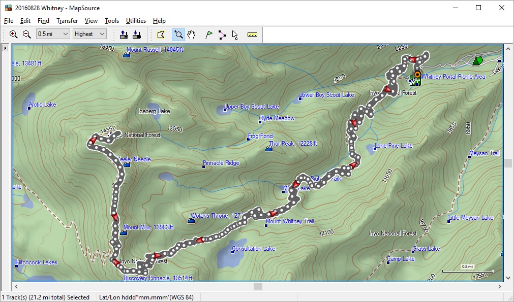
GPS track
With a relatively minor exception at 13,600 feet elevation, between Trail Crest and the John Muir Trail junction, the trail simply climbs monotonically from the trailhead to the summit. The section between 12,000 and 13,600 feet elevation – the switchbacks – is the steepest section of the trail; the grade here is about 15.5%.

Elevation profile
At the summit there is a commemorative tablet noting the construction time period. The last ~2 miles of the Mt Whitney Trail is also the last section of the John Muir Trail and the High Sierra Trail.

Commemorative tablet at the summit of Mt Whitney
There are also at least three geodetic markers embedded in the rocks at the actual summit. This is the only one that actually says Whitney.

One of the geodetic markers at the summit of Mt Whitney
The elevation at the top of Mt Whitney is reported at different values: First, note that the commemorative tablet states 14,497 feet; I presume that more accurate surveying has been conducted since the tablet was placed in 1930. The reference book states 14,505 feet, while the permit (see below) states 14,508 feet. On the geodetic marker that has elevation verbiage, the actual elevation has been covered by a blob of metal.
Next to the summit hut there is a tray-like metal box that houses a ledger. I presume that a ranger or other official person visits the summit once a week or so and, among other things, replaces the ledger sheets with new ones. The day of my summit the sheets were nearly full on both sides, and it was a challenge to find a place to sign in – but eventually I did. Mine is the next-to-last entry:
Whee! – I made it!
It was interesting to read some of the other comments.

My ledger entry at the summit
I arrived at the summit shortly before noon and stayed nearly an hour. An important consequence of the length of the hike is that the descent can end after dark. In fact, only one person in our group of eight made it back to Whitney Portal before dark. Five of us stayed together for the third section of the hike, below Trail Camp.
I had two goals, both relating to darkness. One goal was to exit the Whitney Zone, where a permit is required for either day use or overnight use, in daylight. That way I would be able to return some other time to experience the lower 3 miles of the trail in daylight without the complication of needing a permit. Happily, we exited at 7:20pm with good, but fading, light.

Permit for entering the Whitney Zone
The second goal was to arrive at an especially long water crossing before losing daylight. Ever since we had done this crossing in the dark on the ascent, I’d hoped we could do the return crossing of the balance beam in daylight. We made it just in time, a few minutes after 7:30 pm with the light fading quickly.

A quick photo opportunity on the balance beam
Very shortly after I took this picture we all turned our headlamps back on for the remainder of the hike, about 1 hour 40 minutes.
It was fortunate that we had two cars parked at the trailhead. The first hiker to return, the friend who had invited me to join the group, drove back to Lone Pine and proceeded to plan, with the spouse of one of the other hikers, to get a bountiful take-out meal for everyone. My group of five returned in the second car. The last two hikers returned about 2 1/2 hours later, and three members of the group drove back up to meet (and feed) them.
I would certainly say that the expedition was successful: all 8 of our group successfully summited. Although there were a couple of elevation-related issues*, no one had to turn back early as a result. The weather was just about perfect: it was a clear, sunny day with comfortable temperatures and virtually no wind at the summit. The hike itself is simply amazing, and very beautiful. Following are separate posts describing the ascent, the descent, and my wildflower sightings.
*Addendum: I did have what is likely an elevation-related experience that happened after the hike: I’ll call it post hike swollen feet syndrome. I’d been keeping notes about my weight, partly since I’m aware that I typically drink less than recommended amounts; I’m also lighter than average, around 105 lb. I lost a few pounds during my training blitz, then another pound in the last few days, and yet another pound-plus during the hike, weighing in just under 100 lb the morning after the hike. That day I drove back to the Bay Area from Lone Pine, spending much of the day sitting in my car with few and brief breaks. On the second morning my weight was mysteriously up 3 pounds, and by the middle of the day I’d noticed that one foot and ankle were rather swollen, even though I had not tweaked anything during the hike. On the third morning my weight was up another 2 pounds, and both feet, ankles, and calves were very swollen. Wearing compression socks didn’t help. By the end of the afternoon I decided to consult an advice nurse, who had me go in for some tests that couldn’t be done on the phone. Fortunately cardiac, pulmonary, and deep vein thrombosis concerns were alleviated during my visit to the urgent care clinic. I received instructions to continue wearing the compression socks, drink plenty of fluids, eat a low-sodium diet, elevate my feet at night, and go ahead and walk as usual. I think elevating my feet did the trick: by the next (fourth) morning I was peeing more than usual and my weight was starting to go down. Walking felt great and also seemed to help. My weight continued to drop for three more days, until I was down a full 5 pounds from my peak weight. Now, 7 days after the hike, I hope I have plateaued. At least I feel normal!

Pingback: Mt Whitney Trail: Day Hike from Whitney Portal to the Summit and Back – the ascent | trailhiker
Pingback: Mt Whitney Trail: Day Hike from Whitney Portal to the Summit and Back – the descent | trailhiker
Pingback: Wildflowers along the Mt Whitney Trail | trailhiker
Pingback: Sequoia Riverlands Trust – Lewis Hill Preserve | trailhiker
Pingback: Sequoia National Park – Marble Falls Trail | trailhiker
Pingback: PCT Section O: Bartle Gap to Ash Camp | trailhiker
Pingback: Mt Whitney Trail: Whitney Portal to Outpost Camp (in daylight) | trailhiker
Pingback: Mt Kilimanjaro trek Day 4: Shira 2 camp to Barranco camp via Lava Tower | trailhiker
Pingback: Mt Kilimanjaro trek Day 6: Karanga camp to Barafu base camp | trailhiker
Pingback: Mt Kilimanjaro trek Day 7: Barafu base camp to Uhuru Peak and down to Mweka camp | trailhiker
Pingback: An Active Lifestyle with Growing Limitations | trailhiker