

2020 is the fourth year that Santa Clara County Parks has sponsored its PixInParks Challenge, with seven mostly easy-to-moderate hikes, each in a different county park. The idea of the program is that people go for a pleasant outing in a park, take a picture or selfie at a designated location, and post the picture on social media with specific hashtags. It’s a nice way to get out and visit several county parks for enjoyable outings. This year, due to a temporary issue that limits my walking, I have decided to do the shorter routes suggested for ADA visitors. In this case I did a shortened version of the regular hike.
My fourth PixInParks hike for 2020 was at Santa Teresa County Park in south San Jose, at the southern end of the Santa Teresa Hills. Coyote Peak, located in the county park, is 1,155 feet in elevation and is the highest point in the Santa Teresa Hills. From the peak, as well as from other high areas of the park, one can look northeast to and across the Santa Clara Valley and southwest to and across Almaden Valley. The park includes some 1,673 acres and 17 miles of trails.
As is often the case in February, the park was relatively lush and green. The afternoon was pleasantly, though surprisingly, warm. Not far from the trailhead at the site of the historic Bernal Gulnac-Joice Ranch there is a beautiful, mature valley oak tree (Quercus lobata), a deciduous type of oak. At this time of year the complex branch structure is easy to see and striking.

Valley oak silhouette in Santa Teresa County Park
Just across the trail there was an old wagon, presumably left over from the days when the land was a working ranch. These two pictures illustrate how green the landscape was at the time of my visit.

Wagon, remnant of previous history as a working ranch
As mentioned above, I decided to do an abbreviated version of the recommended “regular” hike rather than the suggested ADA route. The main reason for this was that the destination location was not very far from the trailhead. The full route was a 3-mile loop that I thought would have more elevation gain than the shorter, 2.4-mile, out-and-back route. This image shows my GPS track, with the orange dot denoting the trailhead.

GPS track
The elevation profile shows that there was a net gain of 500 feet for the hike. Because there was some up-and-down after the main climb, the total gain (and loss) turned out to be 600 feet. The average grade for the hike was a little less than 10%, and the grade for the main climb was about 13.5%. Normally, especially for a hike of this length, I would consider this to be a moderate grade. In my current circumstance it was somewhat challenging. However, the hike was pretty, and there was lots to see, so it was still enjoyable.

Elevation profile
Just past the oak tree and wagon there was a trail junction where the Norred Trail goes off to the left. Hikers who do the entire “regular” PixInParks loop in a counterclockwise direction complete the loop here. I continued straight on the Joice Trail. The GPS track suggests that the trail winds around a higher hill, but instead the slightly circuitous route was designed to keep the grade reasonable. At the first big curve to the right, as the trail traverses the hillside, the sunlight was just right to illuminate green tufts of bunchgrasses.

Tufts of bunchgrass on a hillside
As I climbed I passed some California manroot (Marah fabacea) and early-season leaves of common yarrow (Achillea millefolium). There were also some California buttercups (Raununculus californicus), which looked especially cheerful in the sun.

California buttercup
I am always delighted to find red maids (Calandrinia menziesii) in the early spring. They are only open when the sun is relatively bright, and they hide in plain sight when there is insufficient sun. Since I often pass by red maids in situations when the sun is not bright enough for the blossoms to open, it’s a delight when there is sufficient sunlight.

Red maids
When I remembered to stop and look behind me, there were frequent beautiful views of the nearby hills. Here is a lovely view, generally west and along the Santa Teresa Hills, with the flatter floor of the populous Santa Clara Valley at the right.

View of Santa Teresa Hills
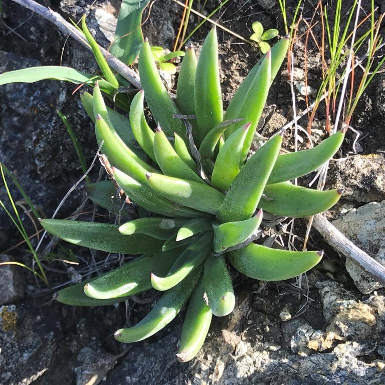
Many areas of Santa Teresa County Park are serpentine; that is, there are serpentine rocks and the soil, derived from the rocks, is also serpentine. The nutrients of serpentine soil are different from other types of soil, and only certain plants grow well in serpentine soil. One such plant, even more special than others that prefer serpentine soil, is Santa Clara Valley dudleya (Dudleya abramsii ssp setchellii). It has been classified in California as category 1B.1 (rare, threatened, or endangered) and is also federally listed as endangered. Needless to say, it is forbidden to disturb these plants in any way, wherever they might be encountered. This plant is endemic to the Santa Clara Valley and a very few nearby areas.

Santa Clara Valley Dudleya
After rounding the third curve in Joice Trail, there is another junction, with Joice Trail going off to the right and Bernal Hill Trail continuing straight. This junction is near some power lines. In fact, there was kind of a junction of power lines, and the wires made interesting geometric patterns against a brilliant cloudless blue sky.
The Bernal Hill Trail traverses east-west, with small undulations and with trees, chaparral, and other vegetation along the trail. At a break in the vegetation there is a pretty view to the northeast, across the Santa Clara Valley, of the Diablo Range and Mt Hamilton – specifically the bright white buildings of Lick Observatory, which are especially visible in the afternoon sun. The summit of Mt Hamilton actually incorporates several peaks, with Copernicus Peak the highest at 4,360 feet. Mt Hamilton is 12 miles away.

View of Mt Hamilton and Lick Observatory buildings
After the traverse, Bernal Hill Trail makes a sharp turn to the right and shortly reaches a gradual high point. From this location there are views in several directions. But first my attention was captured by a male Anna’s hummingbird (Calypte anna), which perched on the highest leafless branch of a shrub and proceeded to survey the area. I watched this little guy off and on for over 5 minutes, and he stayed still long enough for me to observe from different directions relative to the sunlight. I was hoping to get a good picture with both the main body’s green feathers and the pink-red head, throat, and chest feathers gleaming in the sunlight. Though I didn’t quite succeed with the head, at least the body feathers look shiny! This hummingbird is about 4 inches long and weighs just 0.1-0.2 ounce.

Anna’s hummingbird (male)
A small row of serpentine rocks at the local “high point” was the location for the PixInParks photo, just about 1.2 miles from the trailhead. I think the recommended direction to take the photo was from the opposite side of the rocks, but I decided to take my picture with the sun illuminating my day pack. (Since I usually hike solo, I take a picture of my hiking equipment rather than a poor selfie.)

PixInParks photo for Santa Teresa County Park
Looking in the other direction, almost into the sun, there was a clear view of Loma Prieta, epicenter of the 1989 earthquake. Its 3,790-foot summit is decorated with TV and other communications towers. In the picture, a later stretch of the Bernal Hill Trail is visible weaving across a hillside.

View of Santa Cruz Mountains and Loma Prieta
After taking my PixInParks pictures I started to make my way back to the trailhead. Sometimes on the return leg of an out-and-back hike I see different plants or other features. For example, I stopped to admire some soap plants (Chlorogalum pomeridianum), often called wavy leaf soap plant. The leaves are so distinctive that it is one of relatively few plants I can confidently identify outside of its blooming season (May – August). The flowers are beautiful, and they are somewhat unusual because the blossoms open at night and then last just one day. Presumably pollination is carried out by night-active insects.

Wavy leaf soap plant
On the return leg of an out-and-back hike there are often different views from the outbound leg. For this hike, there were views of the North Coyote Valley, which is southeast of the Santa Clara Valley. There was also a view across south San Jose toward the downtown area, perhaps 8-10 miles away.

View of downtown San Jose
Although I had noticed several California poppies (Eschscholzia californica) on the first part of the hike, I stopped for more pictures on the return trip. Here is one that was particularly beautiful in the sunlight.

California poppy
There were also some Bermuda buttercups (Oxalis pes-caprae). This plant is considered to be an invasive non-native, and it seems to be getting more and more common and widespread, both in residential yards and in parks and open spaces. The designation as invasive is related to how easily it can take over and crowd out native plants. But in a way that’s too bad, since the blossoms themselves are actually quite pretty.

Bermuda buttercup
I stopped a second time at the Santa Clara Valley Dudleyas and found additional interesting-looking individuals.
Santa Clara Valley Dudleya
There was one particular type of plant that I saw several times. In a dormant phase, I don’t know what it is. But it looked interesting, and in some areas it was nicely illuminated in the sun, so I took some pictures. In the absence of an identification, I decided to call it skeleton plant.

Unidentified “skeleton plant”
When I reached the oak tree and wagon, the lighting was different from the beginning of my hike, so I tried some different views of the tree. Here is a close-up I liked, looking up at the sky through a tangle of branches.

Valley oak silhouette
When I reached the trailhead I noticed that there was an informal box of hiking sticks available for people to borrow, along with a nice quotation attributed to John Muir: “In every walk with nature, one receives far more than one seeks.”

Loaner walking sticks and a John Muir quote
I can’t think of a better thought to complete a pleasant hike in a local open space!

Pingback: Spring colors in the San Francisco Bay Area | trailhiker