

This was the first of four day hikes within a five-day period on the Pacific Crest Trail (PCT): hikes that were done as part of a car camping trip. My home base for the first part of the trip was the Upper Blue Lake expansion campground, located south of Carson Pass and accessed via Blue Lakes Rd.
The title for this hike is slightly inaccurate, since neither of the endpoints was either Wet Meadows or Pennsylvania Creek. The reason to use the description I did is solely due to space considerations! I started at a road crossing about 1.3 miles north of the Wet Meadows Trail junction, and my turnaround point was about 1 mile south of Pennsylvania Creek, in the 29-mile PCT section between Carson and Ebbetts Passes in the Humboldt-Toiyabe National Forest and in Alpine County.
This section of trail features striking views of nearby peaks as well as a U-shaped journey around a Y-shaped ridge of bizarre and beautiful volcanic rocks and outcrops. For someone more knowledgeable than I am, this hike is a wonderful geology lesson. And I was pleasantly surprised to find several types of wildflower in bloom in spite of the calendar telling me that autumn was right around the corner.
The most distinctive feature of the first (northern) part of the hike is 9065-foot Jeff Davis Peak, shown here. This peak is visible and highly recognizable from a several-mile long stretch of the PCT. From the spot where I took the picture, it is less than 2 miles away almost directly due north.

Jeff Davis Peak
Usually I know the length of a hike before I start; it’s a critical part of the planning process, especially for an out-and-back hike where any mis-calculation gets doubled. In this case there were uncertainties associated with both the start and turnaround points! Although I had hoped to begin my hike at the Wet Meadows trail junction, marked on one of my maps as a trailhead, I was unable to figure out how to get there when I scouted trailheads the previous afternoon. So I had to start at the next accessible location north on the PCT, and this added almost 1.4 miles to each direction. In addition, my intended turnaround point was the turnaround point of a hike I did I 2014 (ping later) and, even with the information in the PCT data book, I wasn’t sure exactly how many trail miles it was from either Wet Meadows or Ebbetts Pass. And my initial estimate turned out to be at least a half mile off, adding that distance (again, in each direction), to my eventual hike length.
The road crossing that served as the start/end point of my hike is located about 3 miles from Blue Lakes Rd on a side road that is signed for the Tamarack PCT trailhead. (In fact, the Tamarack trailhead was the trailhead for the following day’s hike.) After passing the Tamarack trailhead about 1/4 mile from Blue Lakes Rd you continue along the now-gravel road until reaching a T intersection, where you turn left and continue nearly 1/4 mile. This is more properly a road crossing than a trailhead; the PCT is denoted by a modest 4×4 post on either side of the road, neither post signed. There is room for 2-4 cars in nearby informal off-road parking.
The GPS track shows the route of the hike, with the orange dot denoting the road crossing.

GPS track
Using mileages in the PCT data book this hike covered PCT mile 1064.3 to PCT mile 1055.9, or 8.4 miles; my GPS mileage was about 8.6 miles each direction. For reference, the trail distance from the Wet Meadows junction to Pennsylvania Creek – my initial estimate for the hike length – is just under 6 miles.
The elevation profile shows that the elevation range (lowest to highest elevation) was only about 800 feet, but there was quite a bit of up-and-down. The total elevation gain and loss for the 17.1-mile hike was a little over 3300 feet.
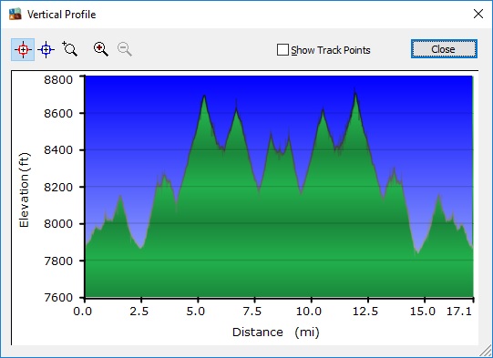
Elevation profile
The road crossing is in a moderately open forested area, and the trail climbs about 250 feet in the first 1.5 miles. Near the end of this climb there is a marked junction with a spur trail to Wet Meadows, mentioned above. Along the first part of the trail I encountered a few checkerblooms (Sidalcia sp.) as well as some Anderson’s thistles (Cirsium andersonii). This one was a rather low-growing individual.

Anderson’s thistle
There is a relatively short section that passes over smooth, bare rock; the way is marked here with three or four cairns. In other areas there are a few isolated boulders, some with very smooth surfaces and colorful veining. This was only a preview of the geology lesson that was to come later on!
Immediately after passing the Wet Meadows junction the PCT enters the Mokelumne Wilderness. About 2 miles from the road crossing the trail crosses the Pleasant Valley Creek, then continues to descend a bit more before climbing again, to 8200 feet elevation. At 8000 feet elevation a signed post reminds hikers that camp fires are not allowed in the wilderness above that elevation. Shortly after I passed this signpost, at a switchback at the northernmost point of the hike, there was a pretty view toward what I presume to be Pleasant Valley, where several branches of the Pleasant Valley Creek join, along with the Raymond Canyon Creek and possibly others. The town of Markleeville is less than 10 – maybe only 7 – miles away in this general direction.

Pretty view of Pleasant Valley
Very close to this view I found a small cluster of lupine, possibly narrow-flowered lupine (Lupinus angustiflorus) or long-spurred lupine (Lupinus arbustus). When researching this wildflower identification I was a bit surprised to find more than one type of white lupine that grows above 2000 meters (about 6600 feet) elevation in Alpine County and flowers in September.

Lupine, possibly narrow-flowered or long-spurred lupine
Between about 3.2 and 3.7 miles from the start the trail is relatively flat and follows along a hillside that is rocky and steep. I found myself focusing on staying on the trail rather than sightseeing-while-hiking. Near the beginning of this section there is a nice view of Raymond Peak, with the trail in the foreground.

Pacific Crest Trail with Raymond Peak in the background
The trail dips down about 100 feet to cross one of the branches of Pleasant Valley Creek. On the way I found one of many clusters of Bloomer’s goldenbush (Ericameria bloomeri). I have seen this pretty shrub many times; before I made this identification I mentally named it “yellow-tipped bush,” since the blossoms are at the tip of each branch.

Bloomer’s goldenbush
Near the creek crossing there were a few of what I believe to be hoary asters (Dieteria canescens var. canescens), with relatively wide ray flowers and bright yellow disc flowers.

Hoary aster near Pleasant Valley Creek
There was also ranger’s button (Sphenosciadum capitellatum), a bit of late-season paintbrush (Castilleja sp.) and seep spring arnica (Arnica longifolia).
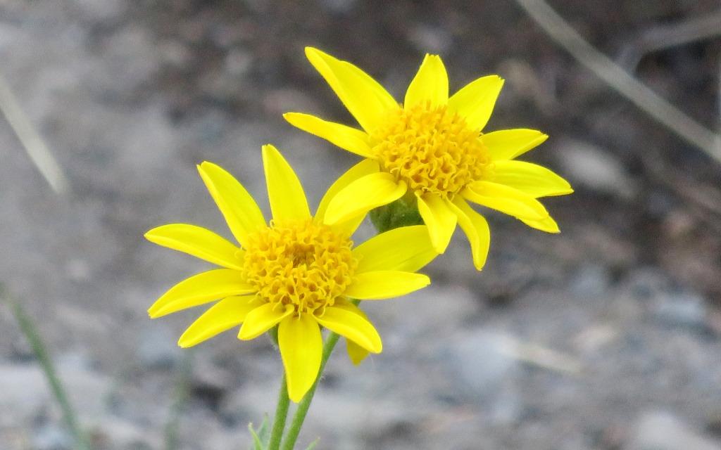
Seep spring arnica
After the Pleasant Valley Creek crossing the trail climbs 600 feet in 1 mile via four switchbacks, the biggest climb of the hike. It’s not really a big climb and, in any case, the grade is a reasonable 11%. About half way up there is a nice view roughly northwest toward several peaks. Jeff Davis Peak is on the right, The Nipple is on the left, and what may be Round Top, about 10 miles away, between them in the background.

View of nearby peaks: Jeff Davis Peak (right), The Nipple (left), and possibly Round Top (center)
Just above 8600 feet elevation is a junction with a trail that goes to Raymond Lake, about 2/3 of a mile away. Although I toyed with the idea of hiking up to the lake, as its setting appeared to be beautiful, I decided I would save it for the return trip – and later decided against making the side trip. This was a good decision in light of the overall length of the hike – and my plan to hike a similar distance the following day.
Shortly past the Raymond Lake trail the PCT tops out at about 8700 feet elevation, the highest elevation of the hike. From here there were nice distant views of the surrounding area, topped off by interesting clouds in the sky.

View from the highest point of the hike
The trail is now about halfway around the U mentioned earlier, and nearly at the top of the Y-shaped ridge formation. The trail continues around the formation, descending 300 feet and regaining 200 feet in the next mile and a half. Not far down from the high point there is another stream crossing, this time Raymond Canyon Creek. Near this crossing I was startled, but delighted, to find clusters of explorer’s gentian (Gentiana calycosa). Gentians are one of my favorite wildflowers, and explorer’s gentians are especially pretty with green stripes and dots on the inner surface of the petals and delicate fringes between the petals.

Explorer’s gentian near Raymond Canyon Creek
As I was passing the gentians I met my first hikers of the day, two women backpackers hiking northbound. It turns out that they were just starting out on a multi-day hike and still getting used to the pack weight. They were impressed that I was managing with such a small pack – until I told them I was only doing a day hike! I was amused that they had apparently assumed I was backpacking, perhaps because of the location relative to trailheads. I only met two other hikers/backpackers during the rest of my hike.
About 1/4 mile further I found a single linanthus plant. I think it is either Sierra linanthus (Leptosiphon pachyphyllus) or Nuttall’s linanthus (Leptosiphon nuttalli); I was unable to distinguish these two species based on my initial research.

Either Sierra or Nuttall’s linanthus
In this moist area I also found some broad-leaf lupine (Lupinus polyphyllus). This is one of relatively few wildflowers that I can recognize outside of its blooming season, because the leaves are so distinctive – even for lupine.
At the crossing of Raymond Canyon Creek I found a couple of larger mountain monkeyflowers (Mimulus tilingii), about 6.1 miles from the start and at the bottom of the 200-foot descent from the highest point of the hike.

Larger mountain monkeyflower at Raymond Canyon Creek
Near the second high point of the hike I found a few more Anderson’s thistles (Cirsium andersonii). Some of the flower heads had completed the blooming cycle and had become the characteristic thistle puff balls typically found late in the season. When viewed up close, I think this phase is also pretty!

Anderson’s thistle puff ball
At the second high point the trail curves to the south and interesting rock formations begin to come into view. These formations are black volcanic rock, and the surfaces are very jagged.

Volcanic rock formations
The trail now descends a little over 400 feet to cross Pennsylvania Creek. On the downhill section I was startled to find some California fuchsia (Epilobium canum). I see this wildflower frequently at sea level in the San Francisco Bay Area, and I was simply surprised to find the same species at over 8000 feet elevation. In addition, I don’t think I have ever looked as closely at the blossom as my camera did in this close-up shot. The petals are quite remarkable!

California fuchsia
Not far away I noted some unusual rocks, which I call cement rocks since I don’t know a more accurate term. These “boulders” are 1-2 feet across. There is clearly a cement-like material between the smaller rocks holding the entire mass together.

“Cement rocks” next to the Pacific Crest Trail
Still on this downhill section I came across a quite remarkable juniper tree, either Sierra juniper (Juniperus grandis) or western juniper (Juniperus occidentalis), growing immediately next to a small rock formation next to the trail. The juniper almost seems to be looking over the rock into the valley formed by the Pennsylvania Creek.
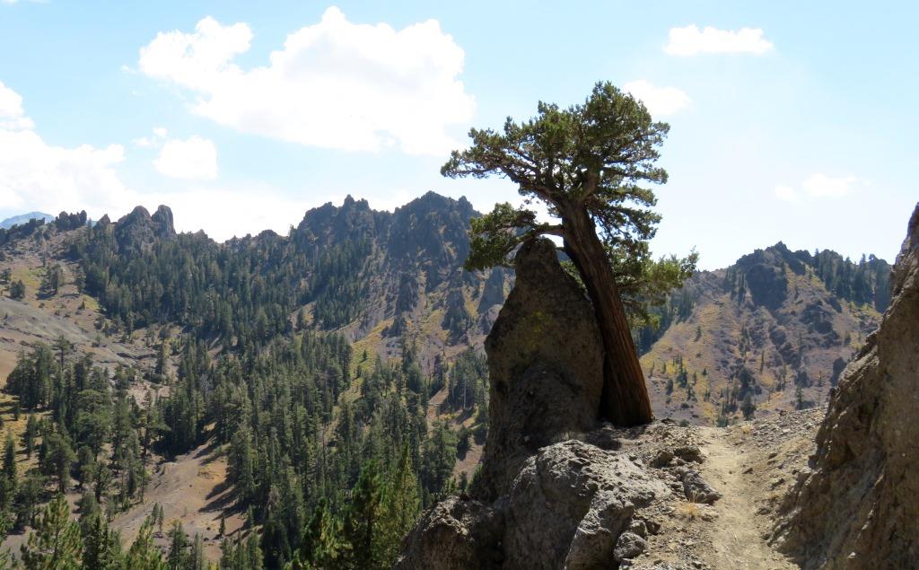
Juniper next to a small rock formation
After the Pennsylvania Creek crossing the PCT climbs up again, this time 300 feet in a half mile, to a saddle, described in the PCT data book as a deep crest saddle. At the saddle there is a sign pointing north to Pennsylvania Creek and south to Eagle Creek. I continued another 0.4 mile past the saddle before I reached the turnaround point of my 2014 hike, where I celebrated with a 15-minute sit-down lunch break. It is noteworthy that I had pre-loaded a waypoint into my GPS so I was able to monitor my approach to the previous turnaround point. I had a great view of some of the nearby fantastic rock formations.

Unusual rock formations near the turnaround point of the hike
After my break I began to retrace my path back to my starting point. After crossing the Raymond Canyon Creek, about 3 miles from the turnaround point, there was a nice view of the nearby hills and ridges beneath an interesting cloud formation.

View of ridges and clouds
Near the beginning of the section that hugged the hillside, where I had to especially pay attention to where I was hiking, I noticed a juniper shrub growing around a colorful rock and loaded with berries. I think it is most likely a common, or dwarf, juniper (Juniperus communis).

Common, or dwarf, juniper loaded with berries
Not far away I noticed that some of the rocks on the uphill side of the trail were partially covered with lichen – not one, but two, kinds. The yellow and orange colors were very bright, almost day-glow colors.

Rocks with colorful lichen
As is often the case, the return trip mirrored the outbound trip. Sometimes I see views differently, because in one direction it’s in front of me and in the other direction it’s behind me. It is a good idea to periodically stop, turn around, and look behind – especially when the trail passes through such a variety of terrain.
This was a great hike in excellent September weather. I was glad I was able to make it to the turnaround point of my 2014 hike. I was highly motivated to do that, and it felt good to have succeeded. It wasn’t just about filling in the blanks, though; it was an excellent hike on its own merits.
For the following day, day 2 of my car camping trip, my hike was planned for the section of PCT north of the Tamarack trailhead.

Pingback: Pacific Crest Trail from a road crossing north of Wet Meadows to the Nipple | trailhiker
Pingback: Pacific Crest Trail from Boulder Lake Trail to Paradise Valley Trail | trailhiker