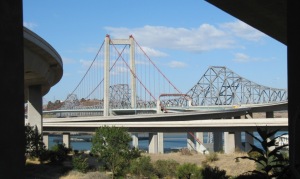
This short walk completed a segment of the Bay Area Ridge Trail from the south end of the Al Zampa Bridge through downtown Crockett. I added a short connection between the end of this segment and the staging area for the segment in Crockett Hills Regional Park. I had previously walked the Al Zampa Bridge from Carquinez, across the Carquinez Strait from Crockett, and I wanted to connect to the Crockett Hills segment. The one-way Ridge Trail distance is only 0.7 miles, plus about 0.4 miles to the beginning of the trail at the far end of the parking area for the Crockett Hills staging area.
I started from the parking lot for the Dead Fish restaurant, the ending point for my earlier walk across the bridge. At the time of that walk I hadn’t realized that the dedicated portion of the Ridge Trail had been extended through downtown Crockett.
Signage directs bicyclists to a bike lane and pedestrians to the sidewalk on the north side of Pomona Street, which passes under part of the bridge approach. Walking under the approach provided a unique perspective on the bridge, with several ramps and flyovers in view.
The downtown Crockett area is relatively small, and has a small-town feeling in spite of its proximity to I-80 and a significant bridge across the Carquinez Strait, with their associated bustle. Among the downtown businesses is a tattoo parlor with Old West style signage out front.
There was also signage to direct visitors to the What’s on Second antiques store. (I didn’t find any businesses with a name like Who’s on First!)
After arriving at the entrance driveway to the Crockett Hills Staging Area, I walked to the parking area where there are a few buildings related to an earlier use of the land. One of the buildings apparently houses a sizable bee’s nest. I took advantage of the zoom on my camera to take this picture from a safe distance. I was not approached by any of the bees, though several were flying to and from the nest opening.
Returning from the staging area to Pomona St I noticed one, then two, then four hawks soaring to the same location not far off the ground, gradually circling and gaining altitude, and then soaring away. They all seemed to know where to go to find that thermal!
After I returned to the Dead Fish I walked a very short distance up the pedestrian/bike path next to the bridge exit ramp. From there I had a clear view of a freighter, presumably being on- or off-loaded.
I’ve hiked or walked in the area near the shores of the Carquinez Strait several times now, and it seems that each time I have heard a train toot its horn while passing through town. I always imagine that they are Amtrak trains. This time was no exception: a horn tooted as an Amtrak train passed almost below where I was standing on the bridge approach. Somehow it seemed like a fitting way to end my walk.


